St. Peter Port
Saint-Pierre-Port | |
|---|---|
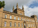
Saint Peter Port, Town Church, Elizabeth College entrance, Castle Pier Lighthouse, Castle Cornet, Victoria Tower, Elizabeth College building, Hauteville House, QE2 Marina | |
 Location of Saint Peter Port on Guernsey, in the Channel Islands | |
| Coordinates: 49°27′20″N 2°32′12″W / 49.4555°N 2.5368°W | |
| Crown Dependency | Bailiwick of Guernsey |
| Government | |
| • Electoral district | Divided into St Peter Port North and St Peter Port South |
| Area | |
| • Total | 6.5 km2 (2.5 sq mi) |
| Elevation | 0 m (0 ft) |
| Population (2019) | |
| • Total | 18,958 |
| • Density | 2,900/km2 (7,600/sq mi) |
| Time zone | GMT |
| • Summer (DST) | UTC+01 |
| Postal code | GY1 |
| Website | www |
St. Peter Port (French: Saint-Pierre Port) is a town and one of the ten parishes on the island of Guernsey in the Channel Islands. It is the capital of the Bailiwick of Guernsey as well as the main port. The population in 2019 was 18,958.
St. Peter Port is a small town (commonly referred to by locals as just "town")[1] consisting mostly of steep narrow streets and steps on the overlooking slopes. It is known that a trading post/town existed here before Roman times with a pre-Christian name which has not survived.
The parish covers an area of 6.5 km2. The postal code for addresses in the parish starts with GY1.
People from St. Peter Port were nicknamed "les Villais" (the townspeople) or "cllichards" in Guernésiais.
- ^ "St Peter Port Guernsey | Guernsey's Capital". www.visitguernsey.com. Retrieved 2021-08-30.


