St. Saviour | |
|---|---|
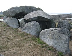
 Le Catioroc (dolmen) in Saint Saviour | |
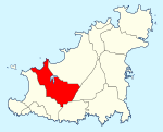
 Location of St. Saviour in Guernsey | |
| Coordinates: 49°27′0″N 2°37′23″W / 49.45000°N 2.62306°W | |
| Crown Dependency | Guernsey, Channel Islands |
| Government | |
| • Electoral district | West |
| Area | |
| • Total | 6.2 km2 (2.4 sq mi) |
| Population (2019) | |
| • Total | 2,765 |
| • Density | 450/km2 (1,200/sq mi) |
| Time zone | GMT |
| • Summer (DST) | UTC+01 |
St Saviour (Guernésiais: Saint Sauveux; French: Saint-Sauveur) is one of the ten parishes of Guernsey. It is situated on the west coast of the island, west of the parish of Castel, east of St Pierre du Bois, and south of Perelle bay.
People from Saint Sauveux were nicknamed "fouormillaons" in Guernésiais, the insular Norman language of the island. The postal code for street addresses in this parish begins with GY7.
