Sainte-Agathe-des-Monts | |
|---|---|
 Sainte-Agathe centre-ville | |
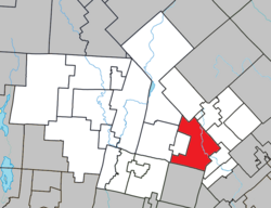
 Location within Les Laurentides RCM | |
| Coordinates: 46°03′N 74°17′W / 46.05°N 74.28°W[1] | |
| Country | |
| Province | |
| Region | Laurentides |
| RCM | Les Laurentides |
| Settled | 1849 |
| Constituted | February 27, 2002 |
| Government | |
| • Mayor | Frédéric Broué |
| • Federal riding | Laurentides—Labelle |
| • Prov. riding | Bertrand |
| Area | |
| • City | 140.9 km2 (54.4 sq mi) |
| • Land | 130.09 km2 (50.23 sq mi) |
| • Metro | 210.96 km2 (81.45 sq mi) |
| Population (2016)[3] | |
| • City | 10,223 |
| • Density | 78.6/km2 (204/sq mi) |
| • Metro | 19,892 |
| • Metro density | 94.3/km2 (244/sq mi) |
| • Pop 2011-2016 | |
| • Dwellings | 6,533 |
| Time zone | UTC−5 (EST) |
| • Summer (DST) | UTC−4 (EDT) |
| Postal code(s) | |
| Area code | 819 |
| Highways | |
| Website | ville |
Sainte-Agathe-des-Monts (French pronunciation: [sɛ̃t aɡat de mɔ̃]) is a town in the province of Quebec, Canada, in the regional county municipality of Les Laurentides in the administrative region of Laurentides, also known as the "Laurentians" or the Laurentian Mountains (in English). Sainte-Agathe-des-Monts borders on a lake called Lac des Sables, and is located approximately 80 kilometres (50 mi) northwest of Montreal, and 130 kilometres (81 mi) northeast of Ottawa.
The town has been twinned with Lagny-sur-Marne, France, since 1969 and Saranac Lake, New York, since 2002.
- ^ Cite error: The named reference
toponymiewas invoked but never defined (see the help page). - ^ a b Cite error: The named reference
mamrotwas invoked but never defined (see the help page). - ^ a b Cite error: The named reference
cp2016was invoked but never defined (see the help page). - ^ a b "Sainte-Agathe-des-Monts (Census agglomeration) census profile". 2021 Census data. Statistics Canada. 15 November 2023. Retrieved 2024-06-16. The census agglomeration consists of Sainte-Agathe-des-Monts, Val-Morin and Val-David.
