Salcete
Saxtti/Xaxtti Salcette | |
|---|---|
Taluka (subdistrict) | |
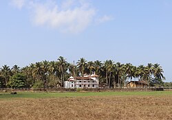
 Salcete countryside | |
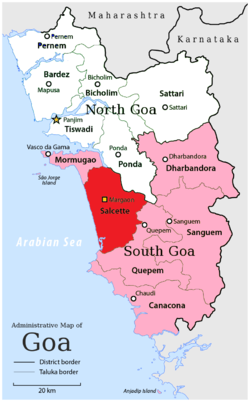
 Location of Salcete in South Goa, Goa | |
| Coordinates: 15°12′45″N 74°04′24″E / 15.212450°N 74.07323°E | |
| Country | |
| State | Goa |
| District | South Goa |
| Headquarters | Margao (Madgaon) |
| Settlements (as of 2011) | 2 cities 11 towns 35 villages |
| Government | |
| • Deputy Collector | Jyoti Kumari, IAS[1] |
| • Talukadar[1] | Prataprao Gaunkar |
| Population (2011)[2] | |
| • Total | 294,504 |
| Demonym | Saxtticar/Xaxtticar |
| PIN | 4036XX, 4037XX |
| Vehicle registration | GA-08 |
Salcete or Salcette (Konkani: Saxtti/Xaxtti) is a subdivision of the district of South Goa, in the state of Goa, situated by the west coast of India.[3] The Sal River and its backwaters dominate the landscape of Salcete.[4] Historically, the sixty-six settlements south of the Zuari River formed the original Salcette territory.[5] Salcete forms a part of the bigger Konkan region that stretches along the western shoreline of peninsular India.[6]
In erstwhile Portuguese Goa, the Salcette concelho (county) located in the Velhas Conquistas (Old Conquests) was co-terminous with the undivided Salcette territory (Mormugao and Salcete talukas).[7] In 1917, the concelho was bifurcated into the present-day talukas of Mormugao and Salcete.[8] The contemporary Salcete taluka has been classified as a rurban area.[9] Margao serves as the administrative headquarters of both Salcete taluka and the South Goa district.[10]
- ^ a b "Who's Who | South Goa District | India". southgoa.nic.in. Archived from the original on 25 March 2021. Retrieved 15 January 2022.
- ^ Cite error: The named reference
salwas invoked but never defined (see the help page). - ^ Sequeira, Newton (21 December 2014). "The true soul of Goa's South". The Times of India. Archived from the original on 8 December 2016. Retrieved 16 April 2020.
- ^ Nambirajan, M. (2007). Coastal Archaeology of Western India: With Special Reference to Goa. Kaveri Books. p. 134. ISBN 9788174790798.
- ^ Rodrigues 1990, p. 231
- ^ Halarnakar, Tanaji D. (1990). Gram Panchayats in Goa: A Critical Study. Rajhauns Vitaran. p. 48.
- ^ Pandit, Heta; Mascarenhas, Annabel; Koshy, Ashok; Dalvi, Sunita (1999). Houses of Goa (2, illustrated ed.). Architecture Autonomous. p. 15.
- ^ Pinho, Vasco (2007). "Snapshots" of Indo-Portuguese history, Volume 1. p. 122.
- ^ Deshpande, Abhijeet. "Exploring Salcete, places near Margao". Indiatimes.com. The Times Group. Archived from the original on 29 April 2021. Retrieved 30 November 2019.
- ^ Deshpande, Abhijeet. "Margao, the cultural capital of Goa". Indiatimes.com. The Times Group. Archived from the original on 22 December 2018. Retrieved 30 November 2019.