| Salmon Gums Western Australia | |||||||||
|---|---|---|---|---|---|---|---|---|---|
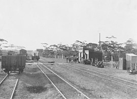
 Salmon Gums railway siding in 1928 | |||||||||
 | |||||||||
| Coordinates | 32°58′48″S 121°38′42″E / 32.98°S 121.645°E | ||||||||
| Population | 146 (SAL 2021)[1] | ||||||||
| Established | 1925 | ||||||||
| Postcode(s) | 6445 | ||||||||
| Elevation | 249 m (817 ft) | ||||||||
| Area | 2,781.5 km2 (1,073.9 sq mi) | ||||||||
| Location | |||||||||
| LGA(s) | Shire of Esperance | ||||||||
| State electorate(s) | Roe | ||||||||
| Federal division(s) | O'Connor | ||||||||
| |||||||||
Salmon Gums is a small town in Western Australia located 106 km north of Esperance on the Coolgardie-Esperance Highway. The name is derived from a prominent stretch of Eucalyptus salmonophloia (Salmon Gum) trees which formed a landmark in the town's early days.[2] The town is part of the Shire of Esperance.[3] At the 2016 census, Salmon Gums had a population of 191.[4]
The surrounding areas produce wheat and other cereal crops. The town is a receival site for Cooperative Bulk Handling.[5]
- ^ Australian Bureau of Statistics (28 June 2022). "Salmon Gums (suburb and locality)". Australian Census 2021 QuickStats. Retrieved 28 June 2022.
- ^ "History of country town names – S". Western Australian Land Information Authority. Archived from the original on 14 March 2022. Retrieved 8 February 2007.
- ^ "General Information". Shire of Esperance. Retrieved 21 June 2020.
- ^ Australian Bureau of Statistics (27 June 2017). "Salmon Gums (State Suburb)". 2016 Census QuickStats. Retrieved 21 June 2020.
- ^ "CBH receival sites" (PDF). 2011. Archived from the original (PDF) on 18 March 2012. Retrieved 1 April 2013.
