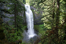
| Salt Creek Falls | |
|---|---|
 | |
 | |
| Location | Lane County, Oregon |
| Coordinates | 43°36′42″N 122°07′43″W / 43.61179°N 122.12861°W |
| Type | Cascade, Plunge |
| Elevation | 3,902 ft (1,189 m) |
| Total height | 286 ft (87 m) |
| Number of drops | 1 |
| Average width | 40 ft (12 m) |
| Watercourse | Salt Creek |
| Average flow rate | 6,684 cu ft/s (189.3 m3/s) |
Salt Creek Falls is a cascade and plunge waterfall on Salt Creek, a tributary of the Middle Fork Willamette River, that plunges into a gaping canyon in the Willamette National Forest near Willamette Pass in Lane County, Oregon. The waterfall is notable for its main drop of 286 feet (87 m), ranking third highest among plunge waterfalls in Oregon, after Multnomah Falls and Watson Falls.[1][2]) The pool at the bottom of Salt Creek Falls waterfall is 66 feet (20 m) deep.
- ^ "Salt Creek Falls". Northwest Waterfall Survey. Retrieved 10 September 2015. Watson Falls was re-measured in 2009 and found to be 293 feet (89 m) rather than an earlier measurement of 272 feet (83 m), surpassing Salt Creek Falls.
- ^ Richard, Terry (January 12, 2014). "Snow isn't essential to enjoy Willamette Pass in Oregon". The Herald. Everett, Washington. Retrieved February 7, 2014.