| Salt Fork Arkansas River Grand Saline River, Kicpahaatihariʾ, Little Arkansas River, Nesuketonga River, Red Fork Arkansas River[1] | |
|---|---|
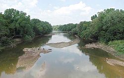
 The Salt Fork at Tonkawa, Oklahoma | |
 Map of the Salt Fork Arkansas watershed | |
| Location | |
| Country | United States |
| State | Kansas, Oklahoma |
| Cities | Alva, OK, Pond Creek, OK, Lamont, OK, Tonkawa, OK |
| Physical characteristics | |
| Source | |
| • location | Comanche County, Kansas |
| • coordinates | 37°10′40″N 99°21′48″W / 37.17778°N 99.36333°W |
| • elevation | 2,042 ft (622 m) |
| Mouth | Arkansas River |
• location | Kay County, Oklahoma |
• coordinates | 36°35′58″N 97°03′11″W / 36.59944°N 97.05306°W[1] |
• elevation | 896 ft (273 m) |
| Length | 239 mi (385 km) |
| Discharge | |
| • location | USGS 07151000 at Tonkawa, OK[2] |
| • average | 927 cu ft/s (26.2 m3/s) |
| • minimum | 0 cu ft/s (0 m3/s) |
| • maximum | 57,800 cu ft/s (1,640 m3/s) |
| Basin features | |
| Tributaries | |
| • left | Medicine Lodge River, Chikaskia River |
| Waterbodies | Great Salt Plains Lake |
| Watersheds | Salt Fork Arkansas-Arkansas- Mississippi |
The Salt Fork of the Arkansas River is a 239-mile-long (385 km)[3] tributary of the Arkansas River in southern Kansas and northern Oklahoma in the United States. Via the Arkansas River, it is part of the watershed of the Mississippi River.
- ^ a b "Salt Fork Arkansas River". Geographic Names Information System. United States Geological Survey, United States Department of the Interior. Retrieved 2015-11-03.
- ^ "Water-Data Report 2013 - 07151000 Salt Fork Arkansas River at Tonkawa, OK" (PDF). U.S. Geological Survey. Retrieved 2015-11-03.
- ^ U.S. Geological Survey. National Hydrography Dataset high-resolution flowline data. The National Map, accessed May 31, 2011