Samcheok
삼척시 | |
|---|---|
| Korean transcription(s) | |
| • Hangul | 삼척시 |
| • Hanja | 三陟市 |
| • Revised Romanization | Samcheok-si |
| • McCune–Reischauer | Samch'ŏk-si |
 | |
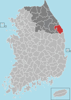
 Location in South Korea | |
| Coordinates: 37°27′00″N 129°09′54″E / 37.450°N 129.165°E | |
| Country | |
| Region | Gangwon Province |
| Administrative divisions | 2 eup, 6 myeon, 4 dong |
| Government | |
| • mayor | Park Sang-su (박상수) |
| Area | |
| • Total | 1,185.78 km2 (457.83 sq mi) |
| Population (September 2024[1]) | |
| • Total | 62,111 |
| • Density | 52/km2 (140/sq mi) |
| • Dialect | Gangwon |
| Area code | +82-33 |
| Climate | Cfa |

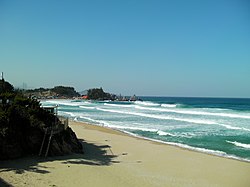
Samcheok (Korean: 삼척; Korean pronunciation: [sa̠m.tɕʰʌ̹k̚]) is a city in Gangwon Province, South Korea. To the west are the Taebaek Mountains, which form a high flat plain of more than 1,000 meters, and to the east, the coastal plain slopes sharply. It borders Donghae in the north, Uljin County in North Gyeongsang Province in the south, and Taebaek in the west. It covers an area of 1,185.86 km2 and has a coastline of 58.4 km.The city hall is located in Gyo-dong, and the administrative area includes 2 districts, 6 villages, and 4 dongs. The tree symbolizing the city is the zelkova, the bird is the seagull, and the flower is the azalea. Samcheok has the lowest population density of any autonomous city in Korea.
- ^ "Population statistics". Korea Ministry of the Interior and Safety. 2024.

