| San | |
|---|---|
 San River in Solina | |
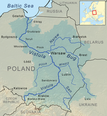
 San River in Vistula watershed | |
| Location | |
| Country | Poland (457 km), Ukraine (1 km) |
| Cities | Lesko, Sanok, Przemyśl, Jarosław, Stalowa Wola |
| Physical characteristics | |
| Source | Uzhok Pass |
| • location | Piniashkovy Mount, Bukovec Mountains, Ukraine |
| • coordinates | 49°00′19″N 22°52′43″E / 49.00528°N 22.87861°E |
| • elevation | 900 m (3,000 ft) |
| Mouth | Vistula |
• location | Dąbrówka Pniowska, Sandomierz Basin, Poland |
• coordinates | 50°44′15″N 21°50′43″E / 50.73750°N 21.84528°E |
| Length | 458 km (285 mi), S → N |
| Basin size | 16,877 km2 (6,516 sq mi) |
| Discharge | |
| • average | 129 m3/s (4,600 cu ft/s) |
| Basin features | |
| Progression | Vistula→ Baltic Sea |
 | |


The San (Polish: San; Ukrainian: Сян Sian; German: Saan) is a river in southeastern Poland and western Ukraine. It is a tributary of the river Vistula. With a length of 458 kilometres (285 mi), the San is the 6th-longest Polish river. It has a basin area of 16,877 km2, of which 14,426 km2 is in Poland.[1]