| San Andres Formation | |
|---|---|
| Stratigraphic range: | |
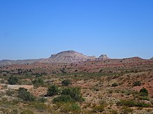
 San Andres Formation near El Malpais National Monument | |
| Type | Formation |
| Sub-units | Bonney Canyon & Fourmile Draw Members |
| Underlies | Grayburg Formation |
| Overlies | Glorieta & Yeso Formations |
| Thickness | 400 m (1,300 ft) |
| Lithology | |
| Primary | Limestone |
| Other | Dolomite, sandstone |
| Location | |
| Coordinates | 33°14′10″N 106°45′36″W / 33.236°N 106.760°W |
| Approximate paleocoordinates | 4°24′N 33°30′W / 4.4°N 33.5°W |
| Region | Texas New Mexico |
| Country | |
| Extent | San Juan Basin (subsurface) San Andres, Zuni & Sangre de Cristo Mountains (outcrop) |
| Type section | |
| Named for | San Andres Mountains |
| Named by | W.T. Lee |
| Year defined | 1909 |

The San Andres Formation is a geologic formation found in New Mexico and Texas. It contains fossils characteristic of the late Leonardian (Kungurian) Age) of the Permian Period.[1]
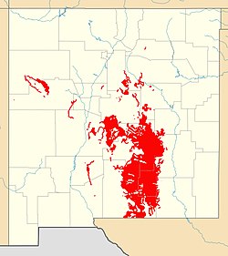
The formation is the most widely exposed Paleozoic formation in the state of New Mexico, cropping out in a zone 80–110 kilometers (50–68 mi) wide that extends from west Texas to central New Mexico and with additional exposures in the Zuni Mountains and Sangre de Cristo Mountains. It is also prominent in the subsurface in the San Juan Basin and in eastern New Mexico.[2]
- ^ Kues & Giles 2004, pp. 98–100.
- ^ Kues & Giles 2004, p. 124.
