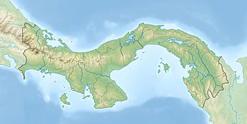
Guna Yala Nickname: Archipiélago de San Blas | |
|---|---|
 Islands entirely covered with dwellings | |
| Geography | |
| Coordinates | 9.57°N, 78.82° W 9°34′N 78°49′W / 9.57°N 78.82°W |
| Total islands | 365 |
| Major islands | 49 |
| Administration | |
The San Blas Islands of Panama is an archipelago comprising approximately 365 islands and cays, of which 49 are inhabited.[1] They lie off the north coast of the Isthmus of Panama, east of the Panama Canal.[2] A part of the comarca (district) Guna Yala along the Caribbean coast of Panama, it is home to the Kuna people.
San Blas and its surrounding area is a haven for ecotourism because of its pristine environs. The area is also popular for sailing, as it is known for its beauty and lack of hurricanes.[3] Notable locations in the Archipelago are the main capital Gaigirgordub, the densely crowded island village of Carti Sugtupu, and the two keys, Cayos Limones, and Cayos Holandeses, both renowned for their clear waters.
The islands could be rendered uninhabitable by sea level rise in the late 21st century.[4] The government of Panama predicted that several islands in the archipelago could be completely submerged by 2050, causing significant displacement requiring plans to move the indigenous residents to the mainland. The island of Carti Sugtupu is currently in the process of having its residents relocated due to frequent floods and rising sea levels, making the community the first in Panama to be displaced by climate change.[5]
- ^ Mersmann, Andrew (2009), Frommer's 500 Places Where You Can Make a Difference, Frommers, p. 306, ISBN 0-470-16061-6
- ^ "San Blas Islands". Google Maps. Retrieved 12 July 2013.
- ^ "Sailing in San Blas Islands". Velero Amande. Archived from the original on 24 June 2013. Retrieved 12 July 2013.
- ^ "Rising Sea Levels Threaten Tiny Islands Home To Indigenous Panamanians". NPR. Archived from the original on 2023-04-04.
- ^ Rodríguez, Juan José. "'Life goes on'—Panama islanders relocated as sea level rises". phys.org. Retrieved 2024-06-10.
