San Luis
Balibago | |
|---|---|
| Municipality of San Luis | |
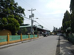
 Central school in San Luis | |
 Map of Batangas with San Luis highlighted | |
Location within the Philippines | |
| Coordinates: 13°50′N 120°56′E / 13.83°N 120.93°E | |
| Country | Philippines |
| Region | Calabarzon |
| Province | Batangas |
| District | 2nd district |
| Founded | August 25, 1861 |
| Annexation to Taal | March 28, 1903 |
| Reestablishment | February 2, 1918 |
| Named for | Louis IX of France |
| Barangays | 26 (see Barangays) |
| Government | |
| • Type | Sangguniang Bayan |
| • Mayor | Oscarlito M. Hernandez |
| • Vice Mayor | Ma-an M. de Gracia |
| • Representative | Gerville Luistro |
| • Municipal Council | Members |
| • Electorate | 25,363 voters (2022) |
| Area | |
| • Total | 42.56 km2 (16.43 sq mi) |
| Elevation | 54 m (177 ft) |
| Highest elevation | 339 m (1,112 ft) |
| Lowest elevation | 0 m (0 ft) |
| Population (2020 census)[3] | |
| • Total | 36,172 |
| • Density | 850/km2 (2,200/sq mi) |
| • Households | 9,299 |
| Economy | |
| • Income class | 4th municipal income class |
| • Poverty incidence | 6.01 |
| • Revenue | ₱ 117.4 million (2020), 52.05 million (2012), 57.1 million (2013) |
| • Assets | ₱ 264.3 million (2020), 53.69 million (2012), 52.34 million (2013) |
| • Expenditure | ₱ 107.1 million (2020) |
| • Liabilities | ₱ 58.08 million (2020), 19.87 million (2012), 15.79 million (2013) |
| Service provider | |
| • Electricity | Batangas 1 Electric Cooperative (BATELEC 1) |
| Time zone | UTC+8 (PST) |
| ZIP code | 4210 |
| PSGC | |
| IDD : area code | +63 (0)43 |
| Native languages | Tagalog |
San Luis, officially the Municipality of San Luis (Tagalog: Bayan ng San Luis), is a 4th class municipality in the province of Batangas, Philippines. According to the 2020 census, it has a population of 36,172 people.[3]
- ^ Municipality of San Luis | (DILG)
- ^ "2015 Census of Population, Report No. 3 – Population, Land Area, and Population Density" (PDF). Philippine Statistics Authority. Quezon City, Philippines. August 2016. ISSN 0117-1453. Archived (PDF) from the original on May 25, 2021. Retrieved July 16, 2021.
- ^ a b Census of Population (2020). "Region IV-A (Calabarzon)". Total Population by Province, City, Municipality and Barangay. Philippine Statistics Authority. Retrieved 8 July 2021.
- ^ "PSA Releases the 2021 City and Municipal Level Poverty Estimates". Philippine Statistics Authority. 2 April 2024. Retrieved 28 April 2024.


