This article needs additional citations for verification. (January 2014) |
San Mariano | |
|---|---|
| Municipality of San Mariano | |
 Aerial view of San Mariano, with Benito Soliven in the foreground and the mighty Cagayan River. | |
| Nickname: Rice Bowl of Isabela | |
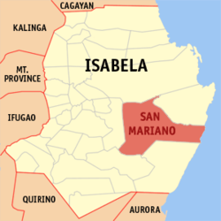
 Map of Isabela with San Mariano highlighted | |
Location within the Philippines | |
| Coordinates: 16°59′N 122°01′E / 16.98°N 122.02°E | |
| Country | Philippines |
| Region | Cagayan Valley |
| Province | Isabela |
| District | 2nd district |
| Founded | 1954 |
| Barangays | 36 (see Barangays) |
| Government | |
| • Type | Sangguniang Bayan |
| • mayor of San Mariano[*] | Edgar T. Go |
| • Vice Mayor | Dean Anthony G. Domalanta |
| • Representative | Ed Christopher S. Go |
| • Electorate | 34,480 voters (2022) |
| Area | |
• Total | 1,469.50 km2 (567.38 sq mi) |
| Elevation | 102 m (335 ft) |
| Highest elevation | 363 m (1,191 ft) |
| Lowest elevation | 28 m (92 ft) |
| Population (2020 census)[3] | |
• Total | 60,124 |
| • Density | 41/km2 (110/sq mi) |
| • Households | 14,448 |
| Economy | |
| • Income class | 1st municipal income class |
| • Poverty incidence | 25.00 |
| • Revenue | ₱ 470.5 million (2020), 180.5 million (2012), 205.4 million (2013), 230.2 million (2014), 262.4 million (2015), 288.2 million (2016), 333.6 million (2017), 361.2 million (2018), 391.2 million (2019), 479 million (2021), 650.1 million (2022) |
| • Assets | ₱ 967.9 million (2020), 288.3 million (2012), 348.3 million (2013), 391.8 million (2014), 378.5 million (2015), 504.9 million (2016), 594.3 million (2017), 682.2 million (2018), 820.4 million (2019), 1,130 million (2021), 1,558 million (2022) |
| • Expenditure | ₱ 410 million (2020), 151.8 million (2012), 171.8 million (2013), 169.3 million (2014), 216.4 million (2015), 270.1 million (2016), 294.6 million (2017), 342.5 million (2018), 323.1 million (2019), 336.8 million (2021), 388.1 million (2022) |
| • Liabilities | ₱ 126.9 million (2020), 58.91 million (2012), 100.7 million (2013), 93.21 million (2014), 190.9 million (2015), 173.3 million (2016), 160.3 million (2017), 122.1 million (2018), 142.4 million (2019), 148.2 million (2021), 233.3 million (2022) |
| Service provider | |
| • Electricity | Isabela 2 Electric Cooperative (ISELCO 2) |
| Time zone | UTC+8 (PST) |
| ZIP code | 3332 |
| PSGC | |
| IDD : area code | +63 (0)78 |
| Native languages | Ilocano Paranan Tagalog |
| Website | www |
San Mariano, officially the Municipality of San Mariano; Ilocano: Ili ti San Mariano; Tagalog: Bayan ng San Mariano), is a 1st class municipality in the province of Isabela, Philippines. According to the 2020 census, it has a population of 60,124 people.[3]
It is also a suburb of Ilagan, the provincial capital.
San Mariano has a total land area of 146,950 hectares (363,100 acres). [5] It constitutes 13.78 percent of the total land area of the province, and is the province's largest and the country's third largest municipality.
The municipality lies in the eastern part of the province of Isabela. It is bounded on the north by the Ilagan, on the east by Palanan, on the south by San Guillermo and on the west by Benito Soliven. It is approximately 404 kilometres (251 mi) from Metro Manila and 46 kilometres (29 mi) from Ilagan, the provincial capital.
- ^ Municipality of San Mariano | (DILG)
- ^ "2015 Census of Population, Report No. 3 – Population, Land Area, and Population Density" (PDF). Philippine Statistics Authority. Quezon City, Philippines. August 2016. ISSN 0117-1453. Archived (PDF) from the original on May 25, 2021. Retrieved July 16, 2021.
- ^ a b Census of Population (2020). "Region II (Cagayan Valley)". Total Population by Province, City, Municipality and Barangay. Philippine Statistics Authority. Retrieved 8 July 2021.
- ^ "PSA Releases the 2021 City and Municipal Level Poverty Estimates". Philippine Statistics Authority. 2 April 2024. Retrieved 28 April 2024.
- ^ "Province: Isabela". PSGC Interactive. Quezon City, Philippines: Philippine Statistics Authority. Retrieved 12 November 2016.


