San Rafael | |
|---|---|
| Municipality of San Rafael | |
 Municipal Hall | |
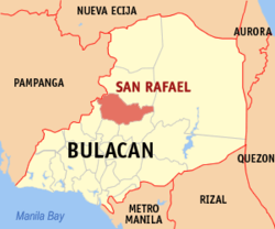
 Map of Bulacan with San Rafael highlighted | |
Location within the Philippines | |
| Coordinates: 14°57′N 120°58′E / 14.95°N 120.97°E | |
| Country | Philippines |
| Region | Central Luzon |
| Province | Bulacan |
| District | 3rd district |
| Founded | September 29, 1750 |
| Annexation to Baliuag | October 8, 1903 |
| Chartered | March 21, 1907 |
| Barangays | 34 (see Barangays) |
| Government | |
| • Type | Sangguniang Bayan |
| • Mayor | Mark Cholo I. Violago |
| • Vice Mayor | Marilyn S. Veneracion |
| • Representative | Lorna C. Silverio |
| • Municipal Council | Members |
| • Electorate | 65,353 voters (2022) |
| Area | |
| • Total | 152.43 km2 (58.85 sq mi) |
| Elevation | 23 m (75 ft) |
| Highest elevation | 69 m (226 ft) |
| Lowest elevation | 8 m (26 ft) |
| Population (2020 census)[3] | |
| • Total | 103,097 |
| • Density | 680/km2 (1,800/sq mi) |
| • Households | 25,220 |
| Economy | |
| • Income class | 1st municipal income class |
| • Poverty incidence | 12.72 |
| • Revenue | ₱ 404.7 million (2020) |
| • Assets | ₱ 1,078 million (2020) |
| • Expenditure | ₱ 300.5 million (2020) |
| • Liabilities | ₱ 274.5 million (2020) |
| Utilities | |
| • Electricity | Meralco |
| Time zone | UTC+8 (PST) |
| ZIP code | 3008, 3025 (Cruz Na Daan) |
| PSGC | |
| IDD : area code | +63 (0)44 |
| Native languages | Tagalog |
| Website | www |
San Rafael, officially the Municipality of San Rafael (Tagalog: Bayan ng San Rafael, Kapampangan: Balen ning San Rafael), is a 1st class municipality in the province of Bulacan, Philippines. According to the 2020 census, it has a population of 103,097 people.[3]
With the continuous expansion of Metro Manila, San Rafael is part of Manila's built-up area which reaches San Ildefonso, Bulacan at its northernmost part.
San Rafael is 37 kilometers (23 mi) from Malolos, the provincial capital, and 60 kilometers (37 mi) from Manila, the country's capital.
- ^ Municipality of San Rafael | (DILG)
- ^ "2015 Census of Population, Report No. 3 – Population, Land Area, and Population Density" (PDF). Philippine Statistics Authority. Quezon City, Philippines. August 2016. ISSN 0117-1453. Archived (PDF) from the original on May 25, 2021. Retrieved July 16, 2021.
- ^ a b Census of Population (2020). "Region III (Central Luzon)". Total Population by Province, City, Municipality and Barangay. Philippine Statistics Authority. Retrieved 8 July 2021.
- ^ "PSA Releases the 2021 City and Municipal Level Poverty Estimates". Philippine Statistics Authority. 2 April 2024. Retrieved 28 April 2024.


