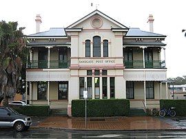
| Sandgate Brisbane, Queensland | |||||||||||||||
|---|---|---|---|---|---|---|---|---|---|---|---|---|---|---|---|
 Former Sandgate post office (now The Sandgate Post Office Hotel) | |||||||||||||||
| Coordinates | 27°19′00″S 153°03′51″E / 27.3167°S 153.0641°E | ||||||||||||||
| Population | 4,926 (2021 census)[1] | ||||||||||||||
| • Density | 1,263/km2 (3,270/sq mi) | ||||||||||||||
| Established | 1853 | ||||||||||||||
| Postcode(s) | 4017 | ||||||||||||||
| Area | 3.9 km2 (1.5 sq mi) | ||||||||||||||
| Time zone | AEST (UTC+10:00) | ||||||||||||||
| Location | 20.5 km (13 mi) NNE of Brisbane CBD | ||||||||||||||
| LGA(s) | City of Brisbane (Deagon Ward)[2] | ||||||||||||||
| State electorate(s) | Sandgate | ||||||||||||||
| Federal division(s) | Lilley | ||||||||||||||
| |||||||||||||||
Sandgate is a northern coastal suburb in the City of Brisbane, Queensland, Australia.[3] In the 2021 census, Sandgate had a population of 4,926 people.[1]
The town became a popular destination for the people of Brisbane in the early 20th century and remains popular due to its coastline, including Lovers Walk along the bay between Sandgate and neighbouring Shorncliffe as well as Moora Park and Beach.
- ^ a b Cite error: The named reference
Census2021was invoked but never defined (see the help page). - ^ "Deagon Ward". Brisbane City Council. Archived from the original on 9 March 2017. Retrieved 12 March 2017.
- ^ "Sandgate – suburb in City of Brisbane (entry 41703)". Queensland Place Names. Queensland Government. Retrieved 26 January 2020.
