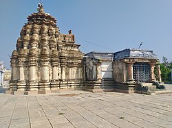
Sangareddy district | |
|---|---|
 Ramalingeshwara temple, Nandikandi | |
 Location in Telangana | |
| Coordinates (Sangareddy): 17.780532, 77.892057 | |
| Country | |
| State | Telangana |
| Mandals | 28 |
| Formation | 11 October 2016[1] |
| Founded by | Government of Telangana, |
| Headquarters | Sangareddy |
| Revenue Divisions | 04 |
| Government | |
| • Type | Zilla Panchayath |
| • Body | Sangareddy Zilla Panchayath |
| • Collector | Dr. A Sharath IAS |
| Area | |
| • Total | 4,996.46 km2 (1,929.14 sq mi) |
| Population (2015) | |
| • Total | 1,526,026 |
| • Density | 310/km2 (790/sq mi) |
| Time zone | UTC+05:30 (IST) |
| Vehicle registration | TG 15 |
| Major highways | |
| Per Capita Income (2022-23) | ₹322,394 (US$3,900) |
| Nominal GDP (2022-23) | ₹60,401.37 crore (US$7.2 billion) [2] |
| Website | sangareddy |
Sangareddy district, is a district located in the western region of the Indian state of Telangana. This district contains a part of the Hyderabad Metropolitan Region.[3]Sangareddy (formerly known as Sangareddy Peta) is the district headquarters of the district. It was named after the ruler Sanga, the son of queen Shankaramba, who was the ruler of Medak during the period of Nizams.[4] The district shares boundaries with Medak, Medchal, Vikarabad, Kamareddy and Rangareddy districts and with the state boundary of Karnataka.
- ^ District Sangareddy, Government of Telangana | India
- ^ https://www.telangana.gov.in/wp-content/uploads/2024/07/Telangana-Socio-Economic-Outlook-2024.pdf
- ^ "Sangareddy district" (PDF). New Districts Formation Portal. Retrieved 11 October 2016.
- ^ "About District- District Sangareddy, Government of Telangana". Telangana State Portal. Government of Telangana. Retrieved 2 January 2024.
