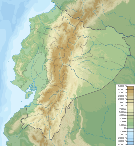
| Sangay | |
|---|---|
 | |
| Highest point | |
| Elevation | 5,286 m (17,343 ft)[1][2] |
| Prominence | 1,588 m (5,210 ft)[3] |
| Listing | Ultra |
| Coordinates | 2°0′9″S 78°20′27″W / 2.00250°S 78.34083°W[4] |
| Naming | |
| English translation | The Frightener[5] |
| Language of name | Quechua |
| Pronunciation | [saŋˈɡaj][needs Quechua IPA] |
| Geography | |
| Location | Ecuador |
| Parent range | Andes |
| Geology | |
| Mountain type | Stratovolcano |
| Volcanic arc/belt | North Volcanic Zone |
| Last eruption | 1934 to 2024 (ongoing)[6] |
| Climbing | |
| First ascent | 4 August 1929[5] |
| Easiest route | Rock/Snow climb[7] |
Sangay (also known as Macas, Sanagay, or Sangai)[8] is an active stratovolcano in central Ecuador. It exhibits mostly strombolian activity. Geologically, Sangay marks the southern boundary of the Northern Volcanic Zone, and its position straddling two major pieces of crust accounts for its high level of activity. Sangay's approximately 500,000-year-old history is one of instability; two previous versions of the mountain were destroyed in massive flank collapses, evidence of which still litters its surroundings today.
Due to its remoteness, Sangay hosts a significant biological community with fauna such as the mountain tapir, giant otter, Andean cock-of-the-rock and king vulture. Since 1979, its ecological community has been protected as part of the Sangay National Park. Although climbing the mountain is hampered by its remoteness, poor weather conditions, river flooding, and the danger of falling ejecta, the volcano is regularly climbed, a feat first achieved by Robert T. Moore in 1929.
- ^ "Ecuador: 15 Mountain Summits with Prominence of 1,500 meters or greater". Peaklist.org. Retrieved 7 May 2015.
- ^ Estimate based on SRTM and ASTER data, which agree that the often quoted elevation of 5230 metres is too low.
- ^ Jonathan de Ferranti and Aaron Maizlish. "Ecuador". Retrieved 10 February 2012.
- ^ "Sangay". Global Volcanism Program. Smithsonian National Museum of Natural History. Retrieved 5 June 2020.
- ^ a b Jason Wilson (2009). The Andes: A Cultural History. Oxford University Press. p. 103. ISBN 978-0-19-538636-3. Retrieved 5 February 2012.
Sangay quechua.
- ^ "Sangay: Weekly Reports". Global Volcanism Program. Smithsonian National Museum of Natural History. Retrieved January 15, 2024.
- ^ Cite error: The named reference
climbwas invoked but never defined (see the help page). - ^ "Sangay: Synonyms and subfeatures". Global Volcanism Program. Smithsonian National Museum of Natural History. Retrieved 5 June 2020.
