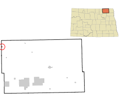
Sarles, North Dakota | |
|---|---|
 Building in Sarles | |
 Location of Sarles, North Dakota | |
| Coordinates: 48°56′41″N 98°59′49″W / 48.94472°N 98.99694°W | |
| Country | United States |
| State | North Dakota |
| Counties | Cavalier, Towner |
| Founded | 1905 |
| Area | |
• Total | 0.26 sq mi (0.68 km2) |
| • Land | 0.26 sq mi (0.68 km2) |
| • Water | 0.00 sq mi (0.00 km2) |
| Elevation | 1,585 ft (483 m) |
| Population | |
• Total | 16 |
• Estimate (2022)[4] | 15 |
| • Density | 61.30/sq mi (23.65/km2) |
| Time zone | UTC-6 (Central (CST)) |
| • Summer (DST) | UTC-5 (CDT) |
| ZIP code | 58372 |
| Area code | 701 |
| FIPS code | 38-70780 |
| GNIS feature ID | 1036254[2] |
Sarles is a city in Cavalier and Towner counties in the State of North Dakota.[5] The population was 16 at the 2020 census.[3] Sarles was founded in 1905 at the end of the Great Northern railway extension north of Munich, called the "Sarles Branch". The town is named for North Dakota Governor Elmore Y. Sarles.[6]
- ^ "ArcGIS REST Services Directory". United States Census Bureau. Retrieved September 20, 2022.
- ^ a b U.S. Geological Survey Geographic Names Information System: Sarles, North Dakota
- ^ a b "Explore Census Data". United States Census Bureau. Retrieved December 14, 2023.
- ^ Cite error: The named reference
USCensusEst2022was invoked but never defined (see the help page). - ^ 2007 Taxable Valuation Survey Archived February 13, 2012, at the Wayback Machine, North Dakota League of Cities
- ^ "The Town Of Sarles", The Bismarck Daily Tribune, June 7, 1905.