Sarmathura | |
|---|---|
Sarmathura City | |
| Coordinates: 26°30′42″N 77°22′11″E / 26.5117°N 77.3698°E | |
| Country | |
| State | Rajasthan |
| District | Dholpur |
| Elevation | 209.630 m (687.762 ft) |
| Population (2011) | |
| • Total | 17,988 |
| Languages | |
| • Official | Hindi, Rajasthani |
| Time zone | UTC+5:30 (IST) |
| PIN | 328026 |
| Telephone code | 05646 |
| ISO 3166 code | RJ-IN |
| Vehicle registration | RJ- |

Sarmathura is a city and subdivision located, near Dholpur city in Dholpur district, in the Indian state of Rajasthan.
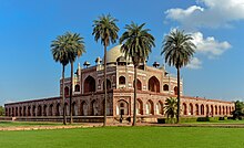
The Sarmathura subdivision is a substantial source of sandstone. Historically, red sandstone from Sarmathura was used for the regional construction of Talab-e-Shahi, Jubilee hall Dholpur, Dholpur Palace and the Nihal Clock Tower.[1] National monuments such as the Red Fort and Humayun Tomb are also made from Dholpur red sandstone, which was extracted from the Sarmathura and Bari area.[2]
The local languages are Hindi, Rajasthani and Khadi Boli. The town's primary exports include red sandstone, sweet millet, and mustard.
Sirmathura was established in the 15th century by Maharaj Shree Rao Mukat (Jadaun) who ruled from Sirmathura an area of 400 sq. km (36 villages) as an independent territory.
- ^ Binayak, Poonam. "Why Rajasthan's Lesser-Known Locations Are Worth Visiting". Culture Trip. Retrieved 5 March 2018.
- ^ "Dholpur - the Land of Red Stone".
