Sarnen | |
|---|---|
 | |
| Coordinates: 46°53′46″N 8°14′44″E / 46.89611°N 8.24556°E | |
| Country | Switzerland |
| Canton | Obwalden |
| District | n.a. |
| Government | |
| • Executive | Gemeinderat with 7 members |
| • Mayor | Gemeindepräsident Jürg Berlinger (as of 2018) |
| • Parliament | none (Gemeindeversammlung) |
| Area | |
| • Total | 70.01 km2 (27.03 sq mi) |
| Elevation (Dorfkapelle) | 471 m (1,545 ft) |
| Population (31 December 2018)[2] | |
| • Total | 10,368 |
| • Density | 150/km2 (380/sq mi) |
| Demonym | German: Sarner(in) |
| Time zone | UTC+01:00 (Central European Time) |
| • Summer (DST) | UTC+02:00 (Central European Summer Time) |
| Postal code(s) | 6056 Kägiswil, 6060 Sarnen, 6060 Ramersberg, 6062 Wilen, 6063 Stalden |
| SFOS number | 1407 |
| ISO 3166 code | CH-OW |
| Localities | Sarnen-Dorfschaft, Kägiswil, Schwendi/Wilen, and Ramersberg |
| Surrounded by | Alpnach, Entlebuch (LU), Flühli (LU), Giswil, Hasle (LU), Kerns, Sachseln |
| Website | www SFSO statistics |
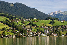
Sarnen is a small historic town, a municipality, and the capital of the canton of Obwalden situated on the northern shores of Lake Sarnen (German: Sarnersee) in Switzerland. It has a population of just over 10,000 and is surrounded by countryside and mountains. Sarnen is located 20 km south of Lucerne.
The official language of Sarnen is (the Swiss variety of Standard) German, but the main spoken language is the local variant of the Alemannic Swiss German dialect.
- ^ a b "Arealstatistik Standard - Gemeinden nach 4 Hauptbereichen". Federal Statistical Office. Retrieved 13 January 2019.
- ^ https://www.pxweb.bfs.admin.ch/pxweb/fr/px-x-0102020000_201/-/px-x-0102020000_201.px. Retrieved 2 June 2020.
{{cite web}}: Missing or empty|title=(help)


