Saugerties, New York | |
|---|---|
 Saugerties from the Hudson | |
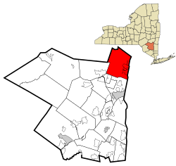
 Location in Ulster County and the state of New York. | |
 U.S. census map of town | |
| Coordinates: 42°04′40″N 73°57′10″W / 42.07778°N 73.95278°W | |
| Country | United States |
| State | New York |
| County | Ulster |
| Area | |
• Total | 67.96 sq mi (176.02 km2) |
| • Land | 64.57 sq mi (167.25 km2) |
| • Water | 3.39 sq mi (8.77 km2) |
| Population (2020) | |
• Total | 19,038 |
| • Density | 280/sq mi (110/km2) |
| Time zone | UTC-5 (EST) |
| • Summer (DST) | UTC-4 (EDT) |
| ZIP code | 12477 |
| Area code | 845 |
| FIPS code | 36-111-65299 |

Saugerties (/ˈsɔːɡərtiːz/) is a town in the northeastern corner of Ulster County, New York. The population was 19,038 at the time of the 2020 census, a decline from 19,482 in 2010. The village of the same name is located entirely within the town.
Part of the town is inside Catskill Park. U.S. Route 9W and New York State Route 32 pass through the town, converging at the center of the village and overlapping to the south. These routes parallel the New York State Thruway (Interstate 87), which passes through the town just west of the village of Saugerties.
- ^ "2016 U.S. Gazetteer Files". United States Census Bureau. Retrieved July 5, 2017.
