Sault Ste. Marie, Michigan | |
|---|---|
| City of Sault Ste. Marie | |
 View of Sault Ste. Marie from the Canadian side of the St. Marys River | |
| Nickname(s): The Sault, The Soo | |
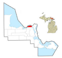
 Location within Chippewa County | |
| Coordinates: 46°29′49″N 84°20′44″W / 46.49694°N 84.34556°W | |
| Country | United States |
| State | Michigan |
| County | Chippewa |
| Established | 1668 |
| Incorporated | 1879 (village) 1887 (city) |
| Government | |
| • Type | Council–manager |
| • Mayor | Don Gerrie |
| • Manager | Brian Chapman |
| Area | |
| • Total | 20.02 sq mi (51.86 km2) |
| • Land | 14.76 sq mi (38.22 km2) |
| • Water | 5.27 sq mi (13.64 km2) 26.74% |
| Elevation | 617 ft (188 m) |
| Population (2020) | |
| • Total | 13,337 |
| • Density | 903.77/sq mi (348.95/km2) |
| Time zone | UTC-5 (EST) |
| • Summer (DST) | UTC-4 (EDT) |
| ZIP code(s) | 49783 |
| Area code | 906 |
| FIPS code | 26-71740 |
| GNIS feature ID | 637276[2] |
| Website | www |
Sault Ste. Marie (/ˌsuː seɪnt məˈriː/ SOO-saynt-mə-REE) is a city in the Upper Peninsula of the U.S. state of Michigan. It is the county seat of Chippewa County and is the only city within the county.[3] With a population of 13,337 at the 2020 census,[4] it is the second-most populated city in the Upper Peninsula, behind Marquette. It is the primary city of the Sault Ste. Marie, MI Micropolitan Statistical Area, which encompasses all of Chippewa County and had a population of 36,785 at the 2020 census. Sault Ste. Marie was settled by mostly French colonists in 1668, making it the oldest city in Michigan.[5]
Sault Ste. Marie is located along the St. Marys River, which flows from Lake Superior to Lake Huron and forms part of the United States–Canada border. Across the river is the larger city of Sault Ste. Marie, Ontario; the two cities are connected by the Sault Ste. Marie International Bridge. Between the two cities are the Soo Locks, a set of locks allowing ship travel between Lake Superior and the Lower Great Lakes.
Sault Ste. Marie is home to Lake Superior State University.[6]
- ^ "2020 U.S. Gazetteer Files". United States Census Bureau. Retrieved May 21, 2022.
- ^ "Sault Ste. Marie". Geographic Names Information System. United States Geological Survey, United States Department of the Interior.
- ^ "Find a County". National Association of Counties. Retrieved June 7, 2011.
- ^ Cite error: The named reference
2020-census-2671740was invoked but never defined (see the help page). - ^ "About Our Community". www.saultcity.com. Retrieved April 17, 2023.
- ^ "About LSSU". Lake Superior State University. Retrieved April 17, 2023.


