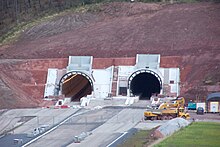
 Western portal in 2013, during construction. | |
| Overview | |
|---|---|
| Official name | Tunnel de Saverne |
| Line | LGV Est |
| Location | Arrondissement of Saverne, Bas-Rhin, Grand Est, France |
| Coordinates | 48°46′49″N 7°21′59″E / 48.78028°N 7.36639°E |
| Status | Completed |
| System | TGV |
| Start | Eckartswiller[1] |
| End | Ernolsheim-lès-Saverne[1] |
| Operation | |
| Work begun | October 2010 |
| Constructed | February 2011 – December 2013[3] |
| Opened | 3 July 2016[2] |
| Owner | SNCF[4] |
| Operator | SNCF |
| Traffic | Train |
| Character | Passenger (High-speed rail) |
| Technical | |
| Design engineer | BG Consulting Engineers |
| Length | 4,000 metres (2.49 mi)[5] |
| Line length | 8,000 m (4.97 mi) (total of both lines, one per tunnel) |
| No. of tracks | single (one per tunnel) |
| Track gauge | 1,435 mm (4 ft 8+1⁄2 in) standard gauge |
| Electrified | 25 kV 50 Hz OHLE |
| Operating speed | 320 kilometres per hour (200 mph) |
| Width | 8.90 m (29.2 ft)[5] |
| Grade | 1.9% (average; 70 m difference between west and east portals)[5] |
| Route map | |
 | |
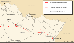
The Saverne Tunnel (French: Tunnel de Saverne), also known as the Ernolsheim-lès-Saverne Tunnel (French: Tunnel d'Ernolsheim-lès-Saverne),[6] is a twin-bore 4-kilometre-long (2.5 mi), high-speed rail tunnel in western Bas-Rhin, France. It carries the LGV Est line of France's TGV high-speed rail network through the narrowest part of the Vosges mountain range, beneath Mont Saint-Michel and adjacent to the Saverne Pass. The tunnel consists of two bores, containing one rail track each, that are connected by passageways every 500 metres (1,600 ft). The LGV Est crosses the 270 m (890 ft) Haspelbaechel viaduct near the western end of the tunnel. The tunnel was excavated by a tunnel boring machine between November 2011 and February 2013. Civil engineering work on the tunnel ended in April 2014 and it opened with the rest of the second phase of the LGV Est on 3 July 2016.[2] The total cost of the tunnel was approximately €200 million.[7]
- ^ a b Géoportail (Map) (in French). Institut national de l’information géographique et forestière. "Croix de Langenthal, 67700 Saint-Jean-Saverne" with the "Parcelles cadastrales" layer activated and superimposed over the "Carte" layer. Archived from the original on 17 September 2016. Retrieved 23 June 2016.
- ^ a b Cite error: The named reference
New opening datewas invoked but never defined (see the help page). - ^ "Le projet". LGV Est Lot 47 (in French). Archived from the original on 17 February 2015. Retrieved 5 June 2015.
- ^ "Quick Overview". SNCF Réseau. Retrieved 14 June 2015.
- ^ a b c "Le Tunnel de Saverne". LGV Est Lot 47 (in French). Archived from the original on 17 February 2015. Retrieved 5 June 2015.
- ^ "Inauguration Ligne LGV - Tunnel d'Ernolsheim-les-Saverne". Dernieres Nouvelles D'Alsace (in French). 2016. Retrieved 5 July 2016.
- ^ Cite error: The named reference
RLwas invoked but never defined (see the help page).