| Scarborough Wollongong, New South Wales | |||||||||||||||
|---|---|---|---|---|---|---|---|---|---|---|---|---|---|---|---|
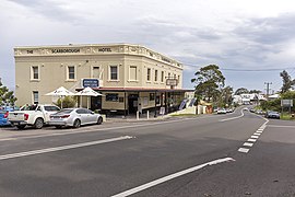
 Scarborough Hotel on Lawrence Hargrave Drive in 2018 | |||||||||||||||
| Coordinates | 34°16′14″S 150°57′37″E / 34.27056°S 150.96028°E | ||||||||||||||
| Population | 325 (2021 census)[1] | ||||||||||||||
| Established | 1903 | ||||||||||||||
| Postcode(s) | 2515 | ||||||||||||||
| Elevation | 78 m (256 ft) | ||||||||||||||
| Location |
| ||||||||||||||
| LGA(s) | City of Wollongong | ||||||||||||||
| State electorate(s) | Heathcote | ||||||||||||||
| Federal division(s) | Cunningham | ||||||||||||||
| |||||||||||||||
Scarborough (/skɑːrbəroʊ/) is a small northern seaside suburb of Wollongong on the south coast of New South Wales, Australia. It sits in the northern Illawarra region on a narrow stretch between the Illawarra escarpment and sea cliffs.
- ^ Australian Bureau of Statistics (28 June 2022). "Scarborough (State Suburb)". 2021 Census QuickStats. Retrieved 30 July 2024.
