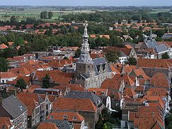
Schouwen-Duiveland | |
|---|---|
 Zierikzee city centre | |
 Location in Zeeland | |
| Coordinates: 51°39′N 3°55′E / 51.650°N 3.917°E | |
| Country | Netherlands |
| Province | Zeeland |
| Established | 1 January 1997[1] |
| Government | |
| • Body | Municipal council |
| • Mayor | Jack van der Hoek |
| Area | |
| • Total | 488.21 km2 (188.50 sq mi) |
| • Land | 229.65 km2 (88.67 sq mi) |
| • Water | 258.56 km2 (99.83 sq mi) |
| Elevation | 0 m (0 ft) |
| Population (January 2021)[5] | |
| • Total | 34,065 |
| • Density | 148/km2 (380/sq mi) |
| Time zone | UTC+1 (CET) |
| • Summer (DST) | UTC+2 (CEST) |
| Postcode | 4300–4329 |
| Area code | 0111 |
| Website | schouwen-duiveland |
Schouwen-Duiveland (Dutch pronunciation: [ˌsxʌu.ə(n) ˈdœyvəlɑnt] ) is a municipality and an island in the southwestern Netherlands province of Zeeland. The municipality has 33,737 inhabitants (1 January 2016) and covers an area of 488.94 square kilometres (188.78 square miles) (of which 257.87 square kilometres (99.56 square miles) is water).
The northside of the island has two fixed connections to Goeree-Overflakkee, the Brouwersdam and the Grevelingen. The southside has two fixed connections to cross the Oosterschelde to North Beveland, the Stormvloed Kering or Oosterscheldedam, part of the Delta Works and the Zeeland Bridge. The island is mostly flat and is, besides a small area, below the sea level. On the western tip is a dune whose highest point is about 42 meters above sea level. The island is, in the summer, very popular with (German) tourists. The Renesse area is a popular holiday destination for young people.
The Brouwersdam is a dam, part of the Delta Works, from Schouwen-Duiveland to Goedereede, the west part of the island of Goeree-Overflakkee in South Holland.
- ^ "Gemeentelijke indeling op 1 januari 1997" [Municipal divisions on 1 January 1997]. cbs.nl (in Dutch). CBS. Retrieved 13 December 2013.
- ^ "Portefeuilleverdeling" [Tasks] (in Dutch). Gemeente Schouwen-Duiveland. Retrieved 13 December 2013.
- ^ "Kerncijfers wijken en buurten 2020" [Key figures for neighbourhoods 2020]. StatLine (in Dutch). CBS. 24 July 2020. Retrieved 19 September 2020.
- ^ "Postcodetool for 4301SH". Actueel Hoogtebestand Nederland (in Dutch). Het Waterschapshuis. Retrieved 13 December 2013.
- ^ "Bevolkingsontwikkeling; regio per maand" [Population growth; regions per month]. CBS Statline (in Dutch). CBS. 1 January 2021. Retrieved 2 January 2022.

