Scottsbluff, Nebraska | |
|---|---|
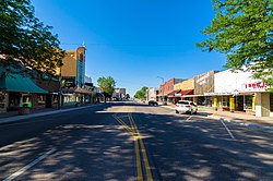
 Looking South on Broadway in Downtown Scottsbluff, July 2017 | |
 Location of Scottsbluff, Nebraska | |
| Coordinates: 41°52′06″N 103°39′52″W / 41.86833°N 103.66444°W | |
| Country | United States |
| State | Nebraska |
| County | Scotts Bluff |
| Founded | 1900 |
| Government | |
| • Mayor | Jeanne McKerrigan |
| Area | |
| • Total | 6.68 sq mi (17.30 km2) |
| • Land | 6.63 sq mi (17.18 km2) |
| • Water | 0.04 sq mi (0.12 km2) |
| Elevation | 3,888 ft (1,185 m) |
| Population (2020) | |
| • Total | 14,436 |
| • Density | 2,176.06/sq mi (840.19/km2) |
| Time zone | UTC−7 (Mountain (MST)) |
| • Summer (DST) | UTC−6 (MDT) |
| ZIP codes | 69361, 69363 |
| Area code | 308 |
| FIPS code | 31-44245 |
| GNIS feature ID | 2396559[2] |
| Website | www.scottsbluff.org |
Scottsbluff is a city in Scotts Bluff County, Nebraska, United States, in the Great Plains region. The population was 14,436 at the 2020 census. Scottsbluff is the largest city in the Nebraska Panhandle, and the 13th-most-populous city in Nebraska.
Scottsbluff was founded in 1899 across the North Platte River from its namesake, a bluff that is now protected by the National Park Service as Scotts Bluff National Monument. The monument was named after Hiram Scott (1805–1828), a fur trader with the Rocky Mountain Fur Company who was found dead in the vicinity on the return trip from a fur expedition. The smaller town of Gering had been founded south of the river in 1887.[3] The two cities have since grown together to form the 7th-largest urban area (the Scottsbluff Micropolitan Statistical Area) in Nebraska.
- ^ "ArcGIS REST Services Directory". United States Census Bureau. Retrieved September 18, 2022.
- ^ a b U.S. Geological Survey Geographic Names Information System: Scottsbluff, Nebraska
- ^ "Hiram Scott". www.nps.gov. U.S. National Park Service. Retrieved February 27, 2021.