This article needs additional citations for verification. (August 2018) |
 | |
| Route information | |
|---|---|
| Length | 30 km (19 mi) |
| Major junctions | |
| North end | Cochin International Airport |
| Kalamassery HMT, Kakkanad, CRL Road Junction | |
| South end | Cochin seaport |
| Location | |
| Country | India |
| States | Kerala: 30 km (19 mi) |
| Primary destinations | Kalamassery - Kakkanad - Irumpanam - Tripunithura - Ernakulam |
| Highway system | |
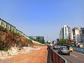
Seaport-Airport Road (SPAP Road) is supposed to be a four-lane, 30 km (19 mi) highway from Cochin seaport to the Cochin International Airport developed to improve the transport infrastructure in the city of Kochi, India. This highway passes through the Cochin Special Economic Zone and connects such major industrial units as HMT, FACT, and Kochi Refineries as also the various oil terminals at Irumpanam and also boosts the flow of cargo traffic both from the port and the airport. The District Headquarters is located on this road. The IT Expressway to Infopark is starting from this road. The 13-km road constructed in the first phase acting as a by-pass to the NH 47 within the Kochi city limits. Petroleum tankers from Irumpanam oil terminals can now move north up to Kalamassery without entering the core city areas. To ensure a smooth and durable road, natural rubber modified bitumen (NRMB) is used.