| Sebastopol Ballarat, Victoria | |||||||||||||||
|---|---|---|---|---|---|---|---|---|---|---|---|---|---|---|---|
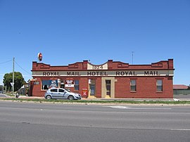
 Royal Mail Hotel | |||||||||||||||
 | |||||||||||||||
| Coordinates | 37°35′7″S 143°50′22″E / 37.58528°S 143.83944°E | ||||||||||||||
| Population | 10,194 (2021 census)[1] | ||||||||||||||
| • Density | 1,205.0/km2 (3,120.8/sq mi) | ||||||||||||||
| Postcode(s) | 3356 | ||||||||||||||
| Area | 8.46 km2 (3.3 sq mi) | ||||||||||||||
| Location | 5 km (3 mi) from Ballarat Central | ||||||||||||||
| LGA(s) | City of Ballarat | ||||||||||||||
| State electorate(s) | Wendouree | ||||||||||||||
| Federal division(s) | Ballarat | ||||||||||||||
| |||||||||||||||
Sebastopol is a southern suburb on the rural-urban fringe of Ballarat, Victoria, Australia. It is the third most populated area in urban Ballarat with a population of 10,194 at the 2021 census.[1]
It is named after Sevastopol in Crimea, the site of an important battle during the Crimean War.
Formerly a separate town, Sebastopol had municipal status between 1864 and 1994 after which the Borough of Sebastopol was merged into the City of Ballarat.
Today it is the site of numerous light-industrial businesses and primarily low cost single-family detached homes and is a fringe suburb in Ballarat and also one of the most car dependent areas in the city.
- ^ a b Australian Bureau of Statistics (28 June 2022). "Sebastopol (State Suburb)". 2021 Census QuickStats. Retrieved 3 November 2022.
