Segundo | |
|---|---|
 A street in Barrio Segundo at dusk, in the Ponce Historic Zone | |
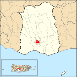
 Location of barrio Segundo within the municipality of Ponce shown in red | |
| Coordinates: 18°00′52″N 66°37′15″W / 18.014444°N 66.620809°W[1] | |
| Commonwealth | |
| Municipality | |
| Area | |
| • Total | 0.53 sq mi (1.4 km2) |
| • Land | 0.53 sq mi (1.4 km2) |
| • Water | 0 sq mi (0 km2) |
| Elevation | 85 ft (26 m) |
| Population (2010) | |
| • Total | 7,213 |
| • Density | 13,609.4/sq mi (5,254.6/km2) |
| Source: 2010 Census | |
| Time zone | UTC−4 (AST) |
Segundo (Barrio Segundo) is one of the 31 barrios of the municipality of Ponce, Puerto Rico. Along with Primero, Tercero, Cuarto, Quinto, and Sexto, Segundo is one of the municipality's six core urban barrios. It was organized in 1878.[3] Barrio Segundo has 3 subbarrios: Baldority de Castro (or just "Baldorioty"), Clausells,[a] and Reparada.[4]
- ^ a b "US Gazetteer 2019". US Census. US Government.
- ^ U.S. Geological Survey Geographic Names Information System: Segundo barrio
- ^ Barrios de Ponce. Antepasados Esclavos.(From: Pedro Tomás de Córdoba. Memorias geográficas, históricas, económicas y estadísticas de la Isla de Puerto Rico.) Retrieved 28 November 2014.
- ^ Puerto Rico:2010:population and housing unit counts.pdf 2010. U.S. Dept. of Commerce. Economics and Statistics Administration. U.S. Census Bureau. Page 74. Accessed 12 February 2019.
Cite error: There are <ref group=lower-alpha> tags or {{efn}} templates on this page, but the references will not show without a {{reflist|group=lower-alpha}} template or {{notelist}} template (see the help page).
