Sekong province
ແຂວງ ເຊກອງ | |
|---|---|
 | |
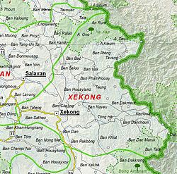
 Map of Sekong province | |
 Location of Sekong province in Laos | |
| Coordinates: 15°43′00″N 106°39′00″E / 15.7166°N 106.65°E | |
| Country | Laos |
| Capital | Sekong |
| Area | |
| • Total | 7,665 km2 (2,959 sq mi) |
| Population (2020 census) | |
| • Total | 129,398 |
| • Density | 17/km2 (44/sq mi) |
| Time zone | UTC+7 (ICT) |
| ISO 3166 code | LA-XE |
| HDI (2017) | medium · 9th |
Sekong (also sometimes Xekong, Lao: ເຊກອງ, pronounced [séː kɔ̀ːŋ]) is a province of Laos in the southeast of the country.
Sekong province is the second smallest province in Laos and also one of its poorest, covering an area of 7,665 square kilometres (2,959 sq mi). It is bordered by Vietnam to the east, Attapeu province to the south, Salavan province to the north, and Champasak province to the west. Sekong also has the smallest population (129,398 as of 2020) and the lowest population density of any province. It was created in 1984 by splitting Salavan province. It is the most diverse province in Laos with 14 ethnic groups. The Sekong River, which divides the province, flows in a southerly direction into Cambodia and is navigable. The river valley has fertile plains interspersed with paddy fields and fruit orchards. Its tropicals forest have many rare species of flora and fauna. The Dakchung Plateau and Xe Xap National Biodiversity Conservation Area are among the areas under protection.
Unlike most of Laos, there are relatively few Buddhist temples (Wat) seen in the province as the predominant belief system is more oriented to animism and ancestral worship. Sekong province is one of the most important coffee-producing areas of Laos.
- ^ "Sub-national HDI - Area Database - Global Data Lab". hdi.globaldatalab.org. Retrieved 2018-09-13.