| Sellicks Hill South Australia | |||||||||||||||
|---|---|---|---|---|---|---|---|---|---|---|---|---|---|---|---|
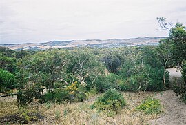
 The Willunga Scarp | |||||||||||||||
| Coordinates | 35°20′S 138°28′E / 35.333°S 138.467°E | ||||||||||||||
| Population | 299 (SAL 2021)[2] | ||||||||||||||
| Established | 1999[1] | ||||||||||||||
| Postcode(s) | 5174[3] | ||||||||||||||
| Location | 48 km (30 mi) South of Adelaide city centre | ||||||||||||||
| LGA(s) | City of Onkaparinga[1] District Council of Yankalilla[1] | ||||||||||||||
| Region | Fleurieu and Kangaroo Island[4] Southern Adelaide[5] | ||||||||||||||
| County | Adelaide[6] | ||||||||||||||
| State electorate(s) | Mawson[7] | ||||||||||||||
| |||||||||||||||
| |||||||||||||||
| Footnotes | Location[3] Climate[8] Adjoining suburbs[1] | ||||||||||||||
Sellicks Hill – formerly spelt Sellick's Hill – is a semi-rural suburb of Adelaide, South Australia. It lies within both the City of Onkaparinga and the District Council of Yankalilla.[1] Before the British colonisation of South Australia, the Sellicks Hill area (along with most of the Adelaide plains area and down the western side of the Fleurieu Peninsula), was inhabited by the Kaurna people.[9] Sellick's Hill Post Office opened on 2 July 1860.[10]
- ^ a b c d e "Search result for "Sellicks Hill (Locality Bounded)" (Record no SA0062060) with the following layers selected – "Suburbs and Localities" and "Local Government Areas"". Department of Planning, Transport and Infrastructure. Retrieved 27 April 2016.
- ^ Australian Bureau of Statistics (28 June 2022). "Sellicks Hill (suburb and locality)". Australian Census 2021 QuickStats. Retrieved 28 June 2022.
- ^ a b "Postcode for Sellicks Hill, South Australia)". postcodes-australia.com. Retrieved 27 April 2016.
- ^ "Fleurieu Kangaroo Island SA Government region" (PDF). The Government of South Australia. Retrieved 17 April 2017.
- ^ "Southern Adelaide SA Government region" (PDF). The Government of South Australia. Retrieved 17 April 2017.
- ^ "Search result for "County of Adelaide, CNTY" with the following data sets selected – "Counties" and "Local Government Areas"". Property Location SA Map Viewer. Government of South Australia. Retrieved 24 April 2017.
- ^ Mawson (Map). Electoral District Boundaries Commission. 2016. Retrieved 2 March 2018.
- ^ "Monthly climate statistics: Summary statistics MYPONGA (nearest station)". Commonwealth of Australia, Bureau of Meteorology. Retrieved 26 April 2016.
- ^ Malone, Gavin Damien Francis (2012). "Chapter 10: Kaurna Ancestor Being Tjilbruke: Commemorations". Phases of Aboriginal Inclusion in the Public Space in Adelaide, South Australia, since Colonisation (PhD). Chapter 10 PDF. Flinders University. Retrieved 17 November 2020.
{{cite thesis}}: External link in|others= - ^ Premier Postal History. "Post Office List". Premier Postal Auctions. Retrieved 26 May 2011.
