This article includes a list of references, related reading, or external links, but its sources remain unclear because it lacks inline citations. (September 2020) |
| Selz | |
|---|---|
 | |
 | |
| Location | |
| Country | Germany |
| State | Rhineland-Palatinate |
| Physical characteristics | |
| Source | |
| • location | Donnersbergkreis |
| • elevation | 321 m (1,053 ft) |
| Mouth | |
• location | Rhine at Ingelheim |
• coordinates | 49°59′45″N 8°1′33″E / 49.99583°N 8.02583°E |
| Length | 63 km (39 mi) |
| Basin size | 375 km2 (145 sq mi) |
| Discharge | |
| • average | 0.77 m3/s (27 cu ft/s) |
| Basin features | |
| Progression | Rhine→ North Sea |
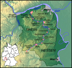
The Selz is a river in Rhineland-Palatinate, Germany, and a left hand tributary of the Rhine. It flows through the largest German wine region, Rheinhessen (Rhenish Hesse).
It rises near the village of Orbis in the county of Donnersbergkreis, crosses the border from the Palatinate into Rhenish Hesse and after about 8 kilometres (5 mi) the town of Alzey in the Alzey-Worms district. There the river passes a pond, and disappears underground, flowing through ditches under the town. On its way it passes through Gau-Odernheim, Nieder-Olm and Ingelheim, before finally discharging into the Rhine in Frei-Weinheim, a district of Ingelheim.
The Selz has a catchment area of 375 square kilometres (145 sq mi) characterised by a warm, dry climate with an average annual precipitation of around 500 millimetres (20 in). Despite its low, and often irregular water flow, the Selz is regarded as the main river in the rather dry rolling countryside of Rhenish Hesse. During periods of low water, its waters consist of a significant amount of clean effluent from sewage farms.