31°30′00″S 53°22′00″W / 31.50000°S 53.36667°W
| Serras de Sudeste | |
|---|---|
| Escudo Sul-Rio-Grandense | |
 | |
| Highest point | |
| Peak | Unclear (possibly Cerro do Sandi) |
| Elevation | 510 m (1,670 ft) |
| Coordinates | 31°30′00″S 53°22′00″W / 31.50000°S 53.36667°W |
| Naming | |
| English translation | Southeastern Mountain Ranges |
| Language of name | Portuguese |
| Pronunciation | Portuguese pronunciation: [ˈsɛʁɐz dʒi suˈdɛstʃi] |
| Geography | |
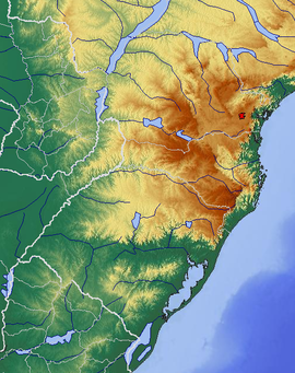
 Topographic map of the Southern Region, Brazil. This plateau is located west of Lagoa dos Patos. | |
| Country | |
| State | |
| Geology | |
| Rock age | Precambrian |
| Mountain type(s) | Dissected plateau (granite, gneiss) |
Serras de Sudeste (English: Southeastern Mountain Ranges) is a dissected plateau, also named Planalto Dissecado de Sudeste (Southeastern Dissected Plateau) or Escudo Sul-Rio-Grandense (Shield of Rio Grande do Sul), located in the southeastern portion of Rio Grande do Sul state in southernmost Brazil, near Uruguay.[1]
- ^ (in Portuguese) Sobre Porto Alegre, 48° Congresso Brasileiro de Geologia - Accessed on 25 January, 2017.