| Seventeen Seventy Queensland | |||||||||||||||
|---|---|---|---|---|---|---|---|---|---|---|---|---|---|---|---|
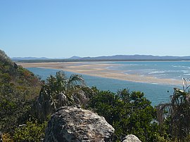
 View out to the bay from Seventeen Seventy, November 2009 | |||||||||||||||
 | |||||||||||||||
| Coordinates | 24°09′48″S 151°53′07″E / 24.1633°S 151.8852°E | ||||||||||||||
| Population | 125 (2021 census)[1] | ||||||||||||||
| • Density | 4.562/km2 (11.82/sq mi) | ||||||||||||||
| Postcode(s) | 4677 | ||||||||||||||
| Area | 27.4 km2 (10.6 sq mi) | ||||||||||||||
| Time zone | AEST (UTC+10:00) | ||||||||||||||
| Location |
| ||||||||||||||
| LGA(s) | Gladstone Region | ||||||||||||||
| State electorate(s) | Burnett | ||||||||||||||
| Federal division(s) | Hinkler | ||||||||||||||
| |||||||||||||||
| |||||||||||||||
Seventeen Seventy, sometimes written 1770 or Town of 1770, is a coastal town and locality in the Gladstone Region, Queensland, Australia.[2][3] In the 2021 census, the locality of Seventeen Seventy had a population of 125 people.[1]
The town is built on the site of the second landing in Australia by James Cook and the crew of the bark HMS Endeavour in May 1770 (and their first landing in what is now the state of Queensland).
- ^ a b Cite error: The named reference
Census2021was invoked but never defined (see the help page). - ^ "Seventeen Seventy – town in Gladstone Region (entry 44530)". Queensland Place Names. Queensland Government. Retrieved 24 December 2020.
- ^ "Seventeen Seventy – locality in Gladstone Region (entry 47286)". Queensland Place Names. Queensland Government. Retrieved 24 December 2020.
