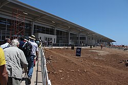
Seymour Galapagos Ecological Airport | |||||||||||
|---|---|---|---|---|---|---|---|---|---|---|---|
 | |||||||||||
| Summary | |||||||||||
| Airport type | Public / Military | ||||||||||
| Serves | Baltra, Galápagos Islands, Ecuador | ||||||||||
| Elevation AMSL | 207 ft / 63 m | ||||||||||
| Coordinates | 00°27′14″S 90°15′57″W / 0.45389°S 90.26583°W | ||||||||||
| Website | www | ||||||||||
| Map | |||||||||||
 | |||||||||||
| Runways | |||||||||||
| |||||||||||


Seymour Galapagos Ecological Airport (Spanish: Aeropuerto Ecológico Galápagos Seymour) (IATA: GPS, ICAO: SEGS) is an airport serving the island of Baltra, one of the Galápagos Islands in Ecuador.
- ^ World Aero Data for SEGS[usurped]
- ^ Airport information for Seymour Airport at Great Circle Mapper.
