Shafter Airport Minter Field | |||||||||||||||
|---|---|---|---|---|---|---|---|---|---|---|---|---|---|---|---|
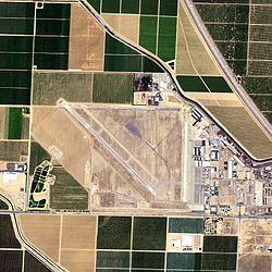
 USGS 2006 orthophoto | |||||||||||||||
| Summary | |||||||||||||||
| Airport type | Public | ||||||||||||||
| Owner | Minter Field Airport District | ||||||||||||||
| Serves | Shafter, California | ||||||||||||||
| Elevation AMSL | 424 ft / 129 m | ||||||||||||||
| Coordinates | 35°30′21″N 119°11′30″W / 35.50583°N 119.19167°W | ||||||||||||||
| Website | www.MinterField.com | ||||||||||||||
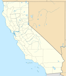
| Map | |||||||||||||||
 | |||||||||||||||
| Runways | |||||||||||||||
| |||||||||||||||
| Statistics (2011) | |||||||||||||||
| |||||||||||||||

Shafter Airport (IATA: MIT, ICAO: KMIT, FAA LID: MIT), also known as Minter Field and formerly known as Air Corps Basic Flying School,[2] is a public use airport located four nautical miles (7.4 km; 4.6 mi) east of the central business district of Shafter and 14 miles northwest of Bakersfield,[2] a city in Kern County, California, United States. Originally a World War II primary training facility for pilots,[2] it is currently a public airport owned by the Minter Field Airport District.[1] This airport is included in the National Plan of Integrated Airport Systems for 2011–2015, which categorized it as a general aviation facility.[3]
- ^ a b FAA Airport Form 5010 for MIT PDF. Federal Aviation Administration. Effective May 31, 2012.
- ^ a b c Salley, Harold E. (1977). History of California Post Offices, 1849-1976. The Depot. p. 142. ISBN 0-9601558-1-3.
- ^ The field was "2011–2015 NPIAS Report, Appendix A" (PDF, 2.03 MB). Federal Aviation Administration. October 4, 2010.
