Shakopee, Minnesota | |
|---|---|
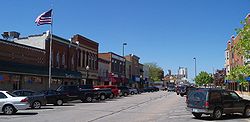
 Downtown Shakopee | |
 Location of the city of Shakopee within Scott County, Minnesota | |
| Coordinates: 44°46′47″N 93°31′38″W / 44.77972°N 93.52722°W | |
| Country | United States |
| State | Minnesota |
| County | Scott |
| Incorporated | 1857 |
| Government | |
| • Mayor | Matt Lehman [citation needed] |
| Area | |
| • City | 30.21 sq mi (78.26 km2) |
| • Land | 28.87 sq mi (74.77 km2) |
| • Water | 1.35 sq mi (3.49 km2) 4.47% |
| Elevation | 830 ft (250 m) |
| Population | |
| • City | 43,698 |
| • Estimate (2022)[4] | 45,735 |
| • Rank | US: 871st MN: 21st |
| • Density | 1,513.72/sq mi (584.45/km2) |
| • Urban | 2,914,866 (US: 16th) |
| • Metro | 3,693,729 (US: 16th) |
| Time zone | UTC-6 (Central) |
| • Summer (DST) | UTC-5 (CDT) |
| ZIP code | 55379 |
| Area code | 952 |
| FIPS code | 27-59350 |
| GNIS feature ID | 2395854[2] |
| Website | shakopeemn.gov |
Shakopee (/ˈʃɑːkəpi/ SHAH-kə-pee)[5] is a city in and the county seat of Scott County, Minnesota, United States. It is southwest of Minneapolis. Sited on the south bank bend of the Minnesota River, Shakopee and nearby suburbs comprise the southwest portion of Minneapolis-Saint Paul, the nation's 16th-largest metropolitan area, with 3.7 million people. The population was 43,698 at the 2020 census.[3]
The riverbank's Shakopee Historic District contains burial mounds built by prehistoric cultures. In the 18th century, Chief Shakopee of the Mdewakanton Dakota established his village on the east end of this area, near the water. Trading led to the city's establishment in the 19th century. Shakopee boomed as a commerce exchange site between river and rail at Murphy's Landing.
Shakopee was once an isolated city in the Minnesota River Valley, but by the 1960s its economy was tied to that of the expanding metropolitan area. Significant growth as a bedroom community occurred after U.S. Highway 169 was realigned in 1996 toward the new Bloomington Ferry Bridge.
The city is known for Valleyfair amusement park and the Canterbury Park racetrack.
- ^ "2020 U.S. Gazetteer Files". United States Census Bureau. Retrieved July 24, 2022.
- ^ a b U.S. Geological Survey Geographic Names Information System: Shakopee, Minnesota
- ^ a b "Explore Census Data". United States Census Bureau. Retrieved August 8, 2022.
- ^ Cite error: The named reference
USCensusEst2022was invoked but never defined (see the help page). - ^ "Minnesota Pronunciation Guide". Associated Press. Archived from the original on July 22, 2011. Retrieved July 4, 2011.

