36°05′N 76°39′E / 36.083°N 76.650°E
| Saksham singh River | |
|---|---|
 | |
| Location | |
| Country | China (disputed by India ) |
| Province | Xinjiang |
| Physical characteristics | |
| Source | Karakoram range |
| • location | Gasherbrum Glaciers |
| • coordinates | 35°36′30″N 77°19′48″E / 35.6084°N 77.33°E |
| Mouth | Yarkand River |
• coordinates | 36°37′36″N 76°12′11″E / 36.626697°N 76.202991°E |
| Basin features | |
| Progression | Yarkand→ Tarim→ Taitema Lake |
| Tributaries | |
| • left | Shimshal Braldu river, Oprang river |
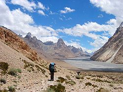
The Shaksgam River (Chinese: 沙克思干河; pinyin: Shakesigan He, Hindi: शक्सगाम नदी, romanized: Shaksgām Nadi, Urdu: دریائے شکسگام, romanized: Daryá-e-Shaksgám) is a left tributary of the Yarkand River. The river is also known as the Kelechin River (Chinese: 克勒青河) and Muztagh River (Chinese: 穆斯塔格河).[1] It rises in the Gasherbrum, Urdok, Staghar, Singhi and Kyagar Glaciers in the Karakoram.[2] It then flows in a general northwestern direction parallel to the Karakoram ridge line in the Shaksgam Valley. It receives the waters of the Shimshal Braldu river and the Oprang river from the Pakistan-administered Hunza District before turning east and joining the Yarkand River. The stretch of the river's course between Shimshal Braldu and Oprang is used as the Pakistan–China border.[3]
Administratively, the Chinese part of the valley is within the southernmost portions of Yarkand County (the source) and the Tashkurgan Tajik Autonomous County (lower course). India claims the entire valley as part of its Jammu and Kashmir state, now part of Ladakh.[4]
- ^ US Bureau of Intelligence and Research International Boundary Study No. 85 (1968) Archived 2012-02-11 at the Wayback Machine
- ^ Hewitt, K. (1982) Natural dams and outburst floods of the Karakoram Himalaya Archived 2011-07-21 at the Wayback Machine
- ^ Shaksgam river basin, OpenStreetMap, retrieved 13 September 2019.
- ^ Boundary of the Trans-Kakarakoram Tract, OpenStreetMap, retrieved 13 September 2019. Saksham Singh river
