This article needs additional citations for verification. (January 2012) |
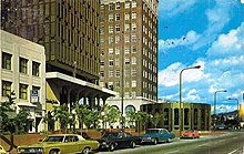
 A 1973 color photocrome postcard of the Downtown Berkeley BART station and Berkeley Chamber of Commerce building | |
| Location | Berkeley and Oakland, California |
|---|---|
| Nearest metro station | |
| Coordinates | 37°52′20″N 122°16′06″W / 37.8721°N 122.2684°W |
| South end | Telegraph Avenue in Oakland's Temescal District |
| Major junctions | |
| North end | Indian Rock Park in the Berkeley Hills |

Shattuck Avenue is a major city street running north–south through Berkeley and Oakland, California. At its southern end, the street branches from Telegraph Avenue in Oakland's Temescal district, then ends at Indian Rock Park in the Berkeley Hills to the north.[1] Shattuck Avenue is the main street of Berkeley, forming the spine of that city's downtown, and the site of the Gourmet Ghetto in North Berkeley. The street was named for Francis Kittredge Shattuck, an early landowner and booster who later served as Mayor of Oakland. Shattuck was largely responsible for the original construction of the road as well as for a railroad built along its route.[2]
- ^ "Shattuck Avenue" (Map). Google Maps. Retrieved June 13, 2023.
- ^ Wollenberg, Charles (2002). Berkeley, A City in History. Retrieved June 13, 2023.