Shelter Cove, California | |
|---|---|
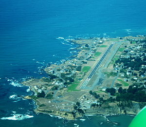
 Shelter Cove as seen from the air | |
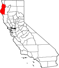
 Location in Humboldt County and the state of California | |
Location in the United States of America | |
| Coordinates: 40°01′50″N 124°04′23″W / 40.03056°N 124.07306°W | |
| Country | |
| State | |
| County | Humboldt County |
| Area | |
• Total | 5.830 sq mi (15.099 km2) |
| • Land | 5.830 sq mi (15.099 km2) |
| • Water | 0 sq mi (0 km2) 0% |
| Elevation | 138 ft (42 m) |
| Population (2020) | |
• Total | 803 |
| • Density | 140/sq mi (53/km2) |
| Time zone | UTC-8 (Pacific (PST)) |
| • Summer (DST) | UTC-7 (PDT) |
| ZIP Code | 95589 |
| Area code | 707 |
| GNIS feature IDs | 1659640; 2611448 |
| U.S. Geological Survey Geographic Names Information System: Shelter Cove, California; U.S. Geological Survey Geographic Names Information System: Shelter Cove, California | |
Shelter Cove is a census-designated place[3] in Humboldt County, California.[2] It lies at an elevation of 138 feet (42 m).[2] Shelter Cove is on California's Lost Coast where the King Range meets the Pacific Ocean. A nine-hole golf course surrounds the one-runway Shelter Cove Airport at the center of Shelter Cove's commercial district. Utilities are provided by the Humboldt County Resort Improvement District #1 and boating access to the sea is managed by the Humboldt Bay Harbor, Recreation & Conservation District. The population was 803 at the 2020 census.
Shelter Cove shares a ZIP code (95589) with the hamlet of Whitethorn, California, located to the southeast. The community is inside telephone area code 707. Sinkyone Wilderness State Park is about 6 miles (9.7 km) south of Shelter Cove on the coast. There are also parks such as Black Sands Beach, Mal Coombs Park, Seal Rock Picnic Area and Abalone Point. Much of the land around Shelter Cove is in the King Range National Conservation Area, managed by the Bureau of Land Management. Cove amenities include hiking trails, deli, coffee shop, restaurants, multiple inns, a general store, and gift shops. Other amenities in Shelter Cove include a small aircraft airstrip, a boat launch, and recreational vehicle parking. Some services not available in Shelter Cove are in the towns of Redway and Garberville on the U.S. 101 corridor, about 20 miles (32 km) of winding county road to the east.
