| Shepparton Victoria | |||||||||
|---|---|---|---|---|---|---|---|---|---|
 Shepparton CBD, communications tower and "Mooving Art" display from Monash Park | |||||||||
| Coordinates | 36°23′S 145°24′E / 36.383°S 145.400°E | ||||||||
| Population | 53,841 (2021 census)[1] | ||||||||
| • Density | 216.32/km2 (560.26/sq mi) | ||||||||
| Established | 24 September 1860[2] | ||||||||
| Gazetted | 28 September 1860 | ||||||||
| Elevation | 116 m (381 ft) | ||||||||
| Area | 248.9 km2 (96.1 sq mi)[3] | ||||||||
| Time zone | AEST (UTC+10) | ||||||||
| • Summer (DST) | AEDT (UTC+11) | ||||||||
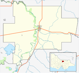
| Location | |||||||||
| LGA(s) | City of Greater Shepparton | ||||||||
| County | Moira | ||||||||
| State electorate(s) | Shepparton | ||||||||
| Federal division(s) | Nicholls | ||||||||
| |||||||||
Shepparton (/ˈʃɛpərtən/)[4] (Yortayorta: Kanny-goopna)[5] is a city located on the floodplain of the Goulburn River in northern Victoria, Australia, approximately 181 kilometres (112 mi) north-northeast of Melbourne. As of the 2021 census, the estimated population of Shepparton, including the adjacent town of Mooroopna, was 53,841.[1]
It began as a sheep station and river crossing in the mid-19th century, before undergoing a major transformation as a railway town. Today it is an agricultural and manufacturing centre, and the centre of the Goulburn Valley irrigation system, one of the largest centres of irrigation in Australia. It is also a major regional service city and the seat of local government and civic administration for the City of Greater Shepparton, which includes the surrounding towns of Tatura, Merrigum, Mooroopna, Murchison, Dookie, Toolamba and Grahamvale.
- ^ a b "2021 Shepparton - Mooroopna (Significant Urban Area), Census All persons QuickStats". Australian Bureau of Statistics. Retrieved 25 July 2023.
- ^ Cite error: The named reference
town-estwas invoked but never defined (see the help page). - ^ "2021 Census Community Profiles: Shepparton - Mooroopna". Australian Bureau of Statistics. Retrieved 25 July 2023.
- ^ Macquarie Dictionary, Fourth Edition (2005). Melbourne: The Macquarie Library. ISBN 1-876429-14-3.
- ^ Clark, Ian D. (2002). Dictionary of Aboriginal placenames of Victoria. Heydon, Toby, 1972-, Victorian Aboriginal Corporation for Languages. Melbourne: Victorian Aboriginal Corp. for Languages. ISBN 0-9579360-2-8. OCLC 54913331.
