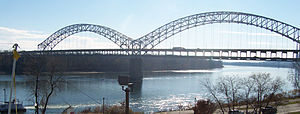
Sherman Minton Bridge | |
|---|---|
 The bridge as seen from the flood wall in New Albany | |
| Coordinates | 38°16′42.44″N 85°49′19.34″W / 38.2784556°N 85.8220389°W |
| Carries | 6 lanes (3 upper, 3 lower) of |
| Crosses | Ohio River |
| Locale | Louisville, Kentucky and New Albany, Indiana |
| Maintained by | Indiana Department of Transportation |
| Characteristics | |
| Design | Double-decked twin tied arch bridge |
| Total length | 2,052.9 ft (625.7 m) |
| Width | 42 ft (13 m) |
| Longest span | 800 ft (240 m) |
| Clearance above | 16.3 ft (5.0 m) |
| History | |
| Opened | December 22, 1961 (lower deck) September 1, 1962 (upper deck) |
| Statistics | |
| Daily traffic | 68,000/day |
| Location | |
 | |
The Sherman Minton Bridge is a double-deck through arch bridge spanning the Ohio River, carrying I-64 and US 150 over the river between Kentucky and Indiana. The bridge connects the west side of Louisville, Kentucky to downtown New Albany, Indiana.