Sherrodsville, Ohio | |
|---|---|
 Village hall | |
 Location of Sherrodsville, Ohio | |
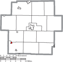
 Location of Sherrodsville in Carroll County | |
| Coordinates: 40°29′42″N 81°14′45″W / 40.49500°N 81.24583°W | |
| Country | United States |
| State | Ohio |
| County | Carroll |
| Area | |
| • Total | 0.32 sq mi (0.82 km2) |
| • Land | 0.32 sq mi (0.82 km2) |
| • Water | 0.00 sq mi (0.00 km2) |
| Elevation | 906 ft (276 m) |
| Population (2020) | |
| • Total | 222 |
| • Density | 702.53/sq mi (271.62/km2) |
| Time zone | UTC-5 (Eastern (EST)) |
| • Summer (DST) | UTC-4 (EDT) |
| ZIP code | 44675 |
| Area code | 740 |
| FIPS code | 39-72242[3] |
| GNIS feature ID | 2399804[2] |
Sherrodsville (/ˈʃɛrɒdzvɪl/ SHERR-odz-vil[4]) is a village in southwestern Carroll County, Ohio, United States. The population was 222 at the 2020 census. It is part of the Canton–Massillon metropolitan area.
- ^ "ArcGIS REST Services Directory". United States Census Bureau. Retrieved September 20, 2022.
- ^ a b U.S. Geological Survey Geographic Names Information System: Sherrodsville, Ohio
- ^ "U.S. Census website". United States Census Bureau. Retrieved January 31, 2008.
- ^ "E.W. Scripps School of Journalism Ohio Pronunciation Guide | Ohio University". www.ohio.edu. Ohio University. 2016. Retrieved December 23, 2022.