Shields, Michigan | |
|---|---|
 Road signage looking east along M-46 | |
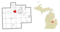
 Location within Saginaw County | |
| Coordinates: 43°25′16″N 84°04′29″W / 43.42111°N 84.07472°W[1] | |
| Country | United States |
| State | Michigan |
| County | Saginaw |
| Townships | James and Thomas |
| Area | |
| • Total | 8.04 sq mi (20.81 km2) |
| • Land | 7.88 sq mi (20.40 km2) |
| • Water | 0.16 sq mi (0.41 km2) |
| Elevation | 604 ft (184 m) |
| Population (2020) | |
| • Total | 7,035 |
| • Density | 892.99/sq mi (344.78/km2) |
| Time zone | UTC-5 (Eastern (EST)) |
| • Summer (DST) | UTC-4 (EDT) |
| ZIP code(s) | 48609 (Saginaw) |
| Area code | 989 |
| FIPS code | 26-73560[3] |
| GNIS feature ID | 2393234[1] |
Shields is an unincorporated community in Thomas Township, Saginaw County in the U.S. state of Michigan. It is also a census-designated place (CDP) for statistical purposes, but with no legal status as an incorporated municipality. The population of the CDP was 7,035 at the 2020 census.
The community of Shields is located on M-46/Gratiot Road just west of the Tittabawassee River.[1] In the 2000 census, the CDP included an area bounded on the east by the Tittabawassee River, north to State Street, west to N. Miller Road, south to Geddes Road, west to N. Thomas Road, south to M-46/Gratiot Road, east to Swan Creek, south to the railroad crossing on Schomaker Road, east along the rail tracks to Stroebel Road, northwest to Ronald Drive and east to the Tittabawassee River. Most of the CDP is within Thomas Township with a small portion extending into northwest James Township.[4]
- ^ a b c d U.S. Geological Survey Geographic Names Information System: Shields, Michigan
- ^ "2020 U.S. Gazetteer Files". United States Census Bureau. Retrieved May 21, 2022.
- ^ "U.S. Census website". United States Census Bureau. Retrieved January 31, 2008.
- ^ Shields CDP, Michigan Reference Map Archived 2020-02-12 at archive.today, U.S. Census Bureau, 2000 census

