| Shiplake | |
|---|---|
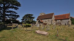
 Parish church of Saint Peter and Paul | |
Location within Oxfordshire | |
| Area | 4.44 km2 (1.71 sq mi) |
| Population | 1,954 (2011 Census) |
| • Density | 440/km2 (1,100/sq mi) |
| OS grid reference | SU7678 |
| Civil parish |
|
| District | |
| Shire county | |
| Region | |
| Country | England |
| Sovereign state | United Kingdom |
| Post town | HENLEY-ON-THAMES |
| Postcode district | RG9 |
| Dialling code | 0118 |
| Police | Thames Valley |
| Fire | Oxfordshire |
| Ambulance | South Central |
| UK Parliament | |
| Website | Shiplake Villages |
Shiplake consists of three settlements: Shiplake, Shiplake Cross and Lower Shiplake. Together these villages form a civil parish situated beside the River Thames 2 miles (3 km) south of Henley-on-Thames, Oxfordshire, England. The river forms the parish boundary to the east and south, and also the county boundary between Oxfordshire and Berkshire. The villages have two discrete centres separated by agricultural land. The 2011 Census records the parish (on its adjusted scale) population as 1,954 and containing 679 homes.[1] The A4155 main road linking Henley with Reading, Berkshire passes through the parish.
The largest settlement is Lower Shiplake, formerly Lashbrook, centred around Shiplake railway station on the Henley Branch Line. It is the economic centre of the parish and contains a store & post office, butcher shop and The Baskerville pub, as well as most of the homes in the parish.
1 mile (1.6 km) southwest of Lower Shiplake are the older, contiguous settlements of Shiplake and Shiplake Cross.The settlement of Shiplake village is the historic and religious centre of the parish and contains Shiplake Farm, the Parish church of Saint Peter & Saint Paul on Church Lane, Shiplake House, The Plough pub and Shiplake College an independent boarding school. The College occupies the building and site of the historic Shiplake Court. Shiplake village contains numerous Grade II listed buildings and monuments.Shiplake Cross is the sporting and community centre of the parish. It consists of just five roads: Memorial Avenue, Orchard Close, Plough Lane, Plowden Way and Schoolfields. It contains the Shiplake Memorial Hall, Shiplake Village Bowling Club (founded 1920) and Shiplake Tennis & Social Club as well as Shiplake CE Primary School and Nursery.
Historically, the parish also included Binfield Heath, 1 mile (1.6 km) west of the historic Shiplake village. Since 2003 it has been a separate civil parish.
- ^ UK Census (2011). "Local Area Report – Shiplake Parish (E04008159)". Nomis. Office for National Statistics. Retrieved 12 February 2020.
