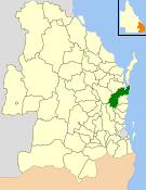
| Shire of Cooloola Queensland | |||||||||||||||
|---|---|---|---|---|---|---|---|---|---|---|---|---|---|---|---|
 Location within Queensland | |||||||||||||||
| Population | 36,956 (2006 census)[1] | ||||||||||||||
| • Density | 12.4481/km2 (32.2405/sq mi) | ||||||||||||||
| Established | 1879 Shire of Widgee 1880 City of Gympie 1993 Shire of Cooloola (merged) | ||||||||||||||
| Area | 2,968.8 km2 (1,146.3 sq mi) | ||||||||||||||
| Council seat | Gympie | ||||||||||||||
 | |||||||||||||||
| Website | Shire of Cooloola | ||||||||||||||
| |||||||||||||||
The Shire of Cooloola was a local government area located about 170 kilometres (106 mi) north of Brisbane – the state capital of Queensland, Australia. The shire covered an area of 2,968.8 square kilometres (1,146.3 sq mi), and was the product of a merger in 1993 between the City of Gympie and the Shire of Widgee, which had both existed since 1879–1880. It merged with several other LGAs to form the Gympie Region on 15 March 2008.
- ^ Australian Bureau of Statistics (25 October 2007). "Cooloola (S) (Local Government Area)". 2006 Census QuickStats. Retrieved 18 March 2008.