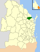
| Shire of Isis Queensland | |||||||||||||||
|---|---|---|---|---|---|---|---|---|---|---|---|---|---|---|---|
 Location within Queensland | |||||||||||||||
| Population | 6,298 (2006 census)[1] | ||||||||||||||
| • Density | 3.6999/km2 (9.5827/sq mi) | ||||||||||||||
| Established | 1887 | ||||||||||||||
| Area | 1,702.2 km2 (657.2 sq mi) | ||||||||||||||
| Council seat | Childers | ||||||||||||||
| Region | Wide Bay–Burnett | ||||||||||||||
 | |||||||||||||||
| Website | Shire of Isis | ||||||||||||||
| |||||||||||||||
The Shire of Isis was a local government area located in the Wide Bay–Burnett region of Queensland, Australia, to the south of Bundaberg. The Shire, administered from the town of Childers covered an area of 1,702.2 square kilometres (657.2 sq mi), and existed as a local government entity from 1887 until 2008, when it was amalgamated with the City of Bundaberg and the Shires of Burnett and Kolan to form the Bundaberg Region.
- ^ Australian Bureau of Statistics (25 October 2007). "Isis (S) (Local Government Area)". 2006 Census QuickStats. Retrieved 14 June 2011.