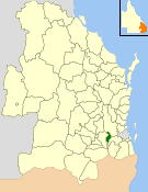
| Shire of Laidley Queensland | |||||||||||||||
|---|---|---|---|---|---|---|---|---|---|---|---|---|---|---|---|
 Location within Queensland | |||||||||||||||
| Population | 14,311 (2006 census)[1] | ||||||||||||||
| • Density | 20.4268/km2 (52.905/sq mi) | ||||||||||||||
| Established | 1888 | ||||||||||||||
| Area | 700.6 km2 (270.5 sq mi) | ||||||||||||||
| Council seat | Laidley | ||||||||||||||
| Region | Lockyer Valley | ||||||||||||||
 | |||||||||||||||
| Website | Shire of Laidley | ||||||||||||||
| |||||||||||||||
The Shire of Laidley was a local government area located in the Lockyer Valley region between the cities of Toowoomba and Ipswich, and about 70 kilometres (43 mi) west of Brisbane, the state capital of Queensland, Australia. The shire covered an area of 700.6 square kilometres (270.5 sq mi), and existed from 1888 until its merger with the Shire of Gatton to form the Lockyer Valley Region on 15 March 2008.
- ^ Australian Bureau of Statistics (25 October 2007). "Laidley (S) (Local Government Area)". 2006 Census QuickStats. Retrieved 18 March 2008.