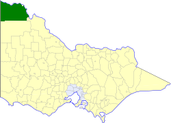
| Shire of Mildura Victoria | |||||||||||||||
|---|---|---|---|---|---|---|---|---|---|---|---|---|---|---|---|
 Location in Victoria | |||||||||||||||
| Population | 21,230 (1992)[1] | ||||||||||||||
| • Density | 2.0927/km2 (5.4200/sq mi) | ||||||||||||||
| Established | 1890 | ||||||||||||||
| Area | 10,145 km2 (3,917.0 sq mi) | ||||||||||||||
| Council seat | Mildura, then Irymple | ||||||||||||||
| Region | Mallee | ||||||||||||||
| County | Karkarooc, Millewa | ||||||||||||||
 | |||||||||||||||
The Shire of Mildura was a local government area located at the northwestern corner of Victoria, Australia, on the Murray River and the South Australian border. The shire covered an area of 10,145 square kilometres (3,917.0 sq mi), and existed from 1890 until 1995. From 1920 onwards, Mildura itself was managed by a separate entity, ultimately known as the City of Mildura.