| Shire of Oxley Victoria | |||||||||||||||
|---|---|---|---|---|---|---|---|---|---|---|---|---|---|---|---|
 Location in Victoria | |||||||||||||||
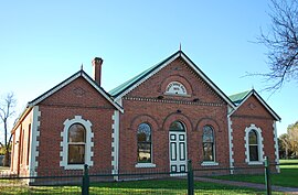
 Oxley Shire Hall | |||||||||||||||
| Population | 5,310 (1992)[1] | ||||||||||||||
| • Density | 1.9038/km2 (4.931/sq mi) | ||||||||||||||
| Established | 1862 | ||||||||||||||
| Area | 2,789.2 km2 (1,076.9 sq mi) | ||||||||||||||
| Council seat | Wangaratta | ||||||||||||||
| Region | Hume | ||||||||||||||
| County | Delatite | ||||||||||||||
| |||||||||||||||
The Shire of Oxley was a local government area in Victoria, Australia, immediately to the south of the city of Wangaratta, which housed the shire's council chambers. Oxley covered an area of 2,789.2 square kilometres (1,076.92 sq mi), and existed from 1862 until 1994.